Sunday, July 5, 2015

Round the South


A Tour of the South by way of the Smoky Mountains, Atlanta, Memphis, and Arkansas

Without much more planning than deciding to go a few weeks prior, we hit the road for a bit of whirlwind tour of the South. The first leg of the journey was the longest, a 12-hour jump to from Kansas City to Gatlinburg. We spent two nights there, and a full day roaming Great Smoky Mountains National Park, and one night wandering the streets of Gatlinburg before heading further south. That routine would be the standard for most of the journey.

The third day out was not quite as much of jump, from Gatlinburg to Fayetteville, Georgia. Since we did not plan to stop nearly as much in Great Smoky Mountains National Park, I experimented with recording the road time on the southern slope of the mountains, and produced this little video with accompaniment from the “Summertime” remix by Armand van Helden. It contains about 5 different videos spliced together, taken from the top of the ridge to near our first stop of the day at the Mountain Farm Museum near Cherokee, North Carolina.


We only made one other significant stop that day. While planning our expedition route, I always scan Google maps for any little geographic item of interest along the route, and stumbled across Tallulah Gorge State Park. That proved a great choice too, and quite a little learning experience packed full of history on multiple levels; pop culture, environmental, and the unusual. We hiked a little further and longer than we planned to, and stopped on the other side of the gorge for a look around too.

South Rim of Tallulah Gorge

On the road again, we had a moment that we thought we should have either not stopped at all, or stayed longer. Just about the time we got in the area of New Holland, we realized that we were going to be just in time for Atlanta rush hour. We pulled into a nearby gas station and quickly queried Google for alternate routes, which indicated it would be no quicker to try to divert, than to just take the plunge and continue on our planned route. I was surprised and very doubtful, having heard horror stories about the traffic in that town, but forged ahead.

Evening Rush Hour in Atlanta

Traffic was heavy, but moving along at a good pace, as we passed into the I-85 corridor in the northeast suburbs of Atlanta. It did not really bog down until we reached downtown though, and then only for a few minutes, for those of us privileged enough to have already secured a position in the HOV lane. At the center of downtown, we met our anticipated fate. All lanes came to a stop. Wall-to-wall traffic crawled along at 10kp/h for about a kilometer or so, and then suddenly, it just broke free again. We were soon doing 110kp/h again, until we reached the exit for Fayetteville. That was when the real fun began, with 13 miles of more heavy traffic and stoplights. We arrived at our destination without incident though, scooped up our good friends, and headed over to the local O’Charley’s for a fantastic meal with our hosts.

Fayetteville Mailbox

We only lingered in Fayetteville for as long as we had in Gatlinburg, but enjoyed the time we had there. Lounging at the pool for most of the day, we later stopped in on the set of the television series The Walking Dead, in Senoia. There really was not much more to the day, but that was the whole intent. We wanted nothing more than to take a little time out of our expedition to enjoy the company of good friends we had not seen in more than year. Later in the evening, we did top off our day with a little rendezvous at the local Hookah Lounge attached to the Khalifa Indian Restaurant. Neither of us had ever been, and it proved to be an interesting experience. The staff was super friendly, and we mostly had the place to ourselves.

A view from the Interstate near the Alabama Line

Back out on the road again the next day, heading west, we dropped in on the birthplace of Elvis Presley. We originally intended to find a hotel in Tupelo, but we arrived much earlier than expected, and decided to push on to Memphis. There was only problem with that idea; reception was terrible until we were about an hour out of Memphis. We secured a room though, at one of the best spots we know of, the downtown Holiday Inn, just a few blocks from Beale Street.
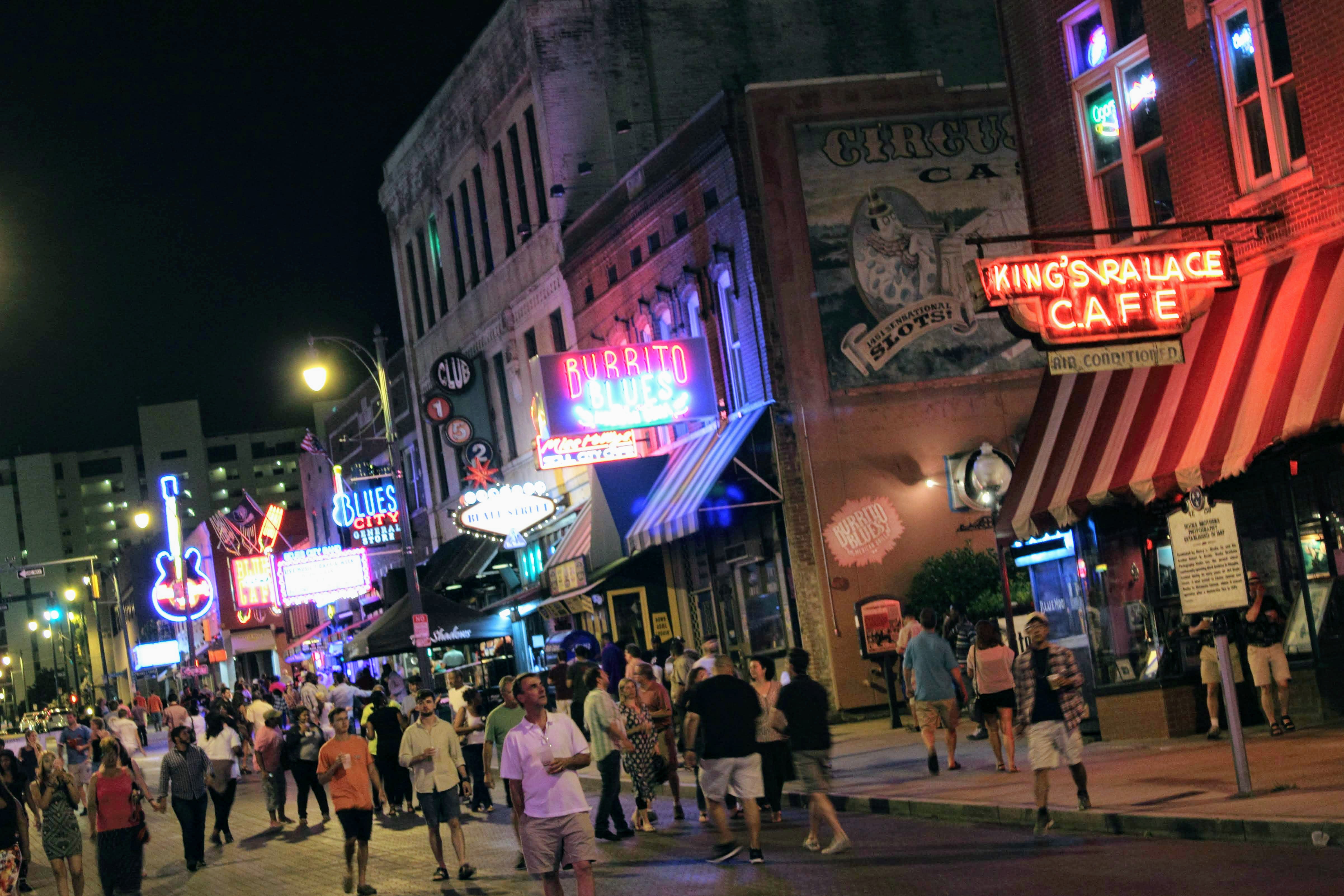
Checking in, we strolled down to Beale Street for a little food and fun to take the edge off the long day on the road. We were not completely sure where we wanted to find food, and soon found ourselves in front of Alfred’s on Beale. We decided that was good enough. They have never disappointed us in the past, and this time was no different.

Alfred’s on Beale Street in Memphis

It was balmy evening in Memphis, like any other in July, and we took our time strolling back up Beale Street. The belly full of BBQ slowed us down a little too. Somebody mentioned something about storms moving in, somewhere along the way, and the wind had picked up a little bit, but it did not seem as though it would happen anytime soon. Siouxsie continued to glance nervously at the sky though, certain it was going to rain any moment. I dismissed it, but probably should not have.
We had just begun to head back up the street, after making another short stop at Silky O’Sullivan’s for quick look around and a cold beer, when the first few drops began to fall. Moments later, the sky unleashed the type of deluge that only really happens down south. It dumped buckets on us, and seemed as though it would never stop. We spent the next 30 minutes running from one overhang to the next in an effort to remain somewhat dry. It was wasted effort. There was no overhang for the last block, and we returned to the hotel soaked.

Bass Pro Shops at the Memphis Pyramid

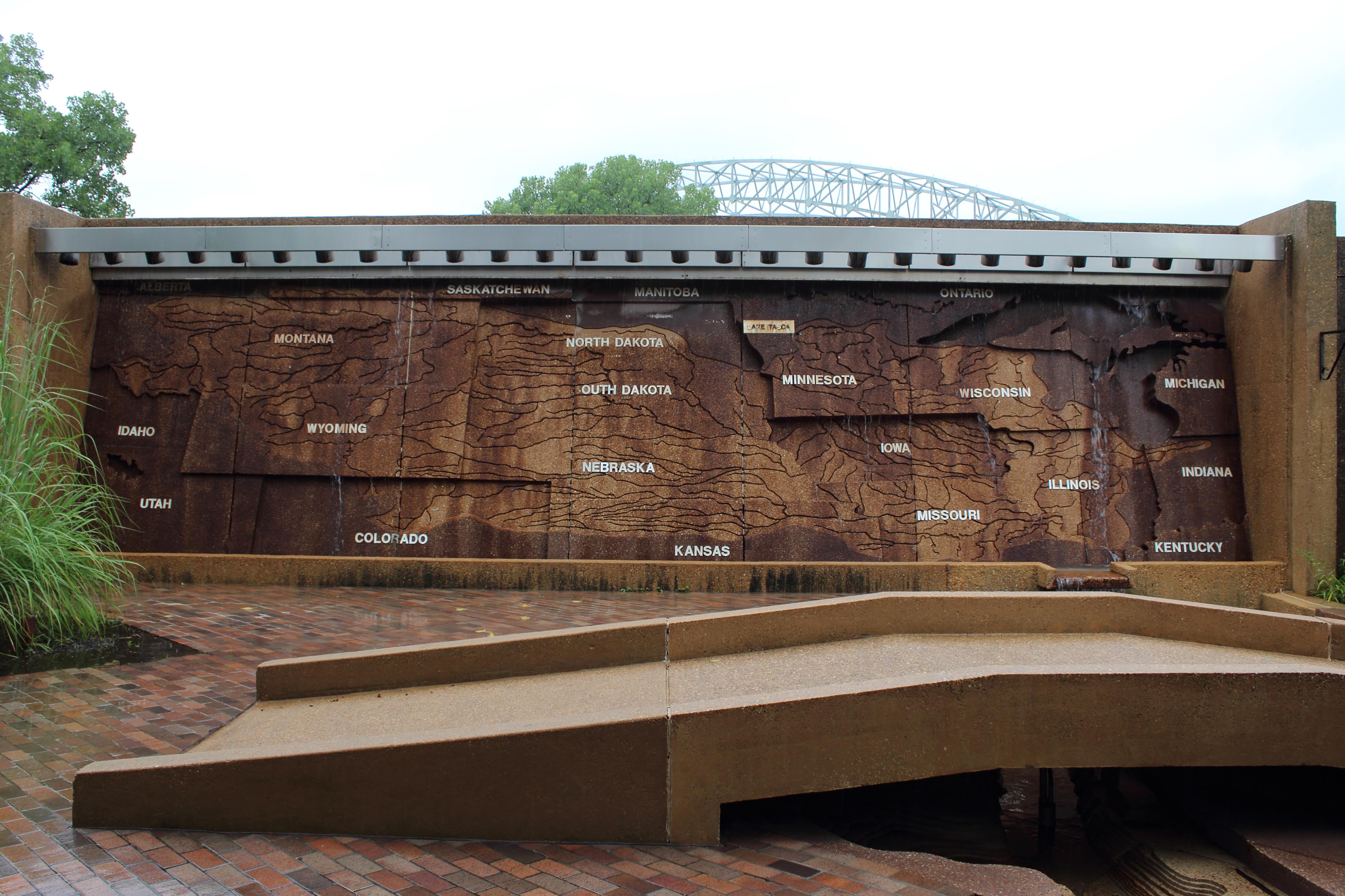
The storm continued most of the night, and into the next morning, and we decided to check out the Bass Pro Shop that had taken over the Pyramid, to see if it would let up. It did somewhat, so we went ahead with our plans to stop in on Mud Island. About the time we reached the end of the model of the Mississippi it started in again, so we decided to move on to brunch and points west.

It did not take long for the skies to clear though. We reached Parkin, just as the last few drops of rain fell, and the clouds began to break. It eventually cleared completely while we were roaming the trail at the State Park. The remainder of the day looked promising, encouraging us to do a little more exploring along the road to our final destination for the day, Heber Springs. We paused long enough Village Creek State Park to tour through by car. Nothing in particular caught our attention, but it appeared to be a nice little getaway necessitating future exploration.

The new Bridal Veil Falls plaque

The journey partially ended in Heber Springs, our home away from home. We enjoyed a short visit with good company and really did not do much of anything. I made a brief visit to Bridal Veil Falls, and discovered they had installed a new plaque/monument detailing a bit of the history. From there, it was the usual trek back to Kansas City. Having traveled that path so many times, there is generally nothing of note along that route; that is, unless we are really looking around. That was not the case for this journey.

. . .

Further Reading

Discovering a light hiking at Tallulah Gorge State Park

A behind the scenes look at the scene of a zombie apocalypse

The first home of Elvis, “King of Rock ‘n Roll”

A history of Delta Blues preserved on Beale

An intriguing interactive cartographic display

A Native American archaeological site and African American Schoolhouse


Friday, July 3, 2015

Parkin Archeological State Park


About a half hour west of Memphis, tucked up against the St Francis River is one of the most significant archaeological discoveries in the Midwest; indeed, very likely one of the most significant in the entire United States.

Parkin Archeological State Park in eastern Arkansas plays host to what many scholars believe to be the Native American village of Casqui, chronicled in the expedition of Hernando de Soto in 1541. Various European-made trade items from the era recovered at the site, along with descriptive text within the journals of Hernando de Soto appear to support the idea.

The Mississippian population flourished at the 17-acre site from as far back as 1000 AD but met its demise shortly after the visit by Hernando de Soto. While the encounter stands as one of the few friendly contacts recorded between Europeans and natives, it is likely they succumbed to disease the Europeans had grown immune to but still carried.

Implements recovered at the site indicate a once prosperous community, but a large platform style mound near the riverbank is all that remains today, along with the deep impression left by the moat excavated by the original inhabitants for protection and irrigation of their crops. We are lucky to have that much left though.


The St Francis River and nearby Tyronza River continued to meander long after the inhabitants vanished, but neither ever fully encroached on the site. When settlement in the area began in the late 1800s, cotton farmers were unable to cultivate across the moat, and the mound presented too much of an obstacle.

The Northern Ohio Cooperage and Lumber Company established a sawmill on the site around 1900, and mill workers developed a community there. Known as Sawdust Hill, headstones still litter the forest floor near another accidental archaeological discovery at the site, associated with the community.

Originally thought to be nothing more than an old hay barn and later converted into a residence used through the 1990s, a unique piece of American history narrowly escaped obliteration. While dismantling interior portions of the structure in preparation for demolition, folks found the Northern Ohio School hiding behind the walls of the home. Immediately cancelling plans for demolition, research began, along with a plan for restoration, completed in 2006. The school now stands as it did, when last used in the 1940s.

Local citizens and elected officials from the nearby town of Parkin impressed upon the University of Arkansas in Fayetteville and the Arkansas Archaeological Society the need for preservation during the 1960s. Designated a National Historic Landmark in 1964, both organizations conducted various surveys shortly after to determine if there were enough intact archaeological deposits to warrant designation as a state park. A partnership developed, resulting in the establishment of a research station, and the site finally designated an Arkansas State Park in 1994.

Currently, the visitor center hosts an on-site research station, a collaborative effort between the two previously mentioned organizations, which continues work on artifacts excavated on the site during that time, as well as recent exploratory excavations. Folks can observe research in progress, view the displays of the results of the work done there, visit an interpretive exhibit area, and enjoy a short film about the park. Educational program, tours, and other special events also occur throughout various times of the year. Outside, an easy three-quarter mile paved trail guides folks through the various points of interest at the site; relatively painless to hike, unless the mosquitos are in full bloom. Access is free, at the time of this writing, excepting the guided walking tours.

. . .

further reading 

Arkansas State Parks

Memphis Mississippi River Map

Google Earth view of Mud Island in Memphis, TN

Situated on what is now a small peninsula between the Mississippi and Wolf Rivers, Mud Island River Park plays host to this scale model of the lower Mississippi River Valley. Corps of Engineers surveys and navigational charts aided in the development of this interactive contour relief map that displays the wanderings of the Mississippi River from its headwaters to the Gulf of Mexico.

The journey begins at four vertical stone waterfall watershed maps. Each map depicts one of the three primary river systems contributing to the drainage of the river, the Arkansas/White, Tennessee/Ohio and Missouri Rivers; the fourth dedicated to the Upper Mississippi River.


At the confluence of the great river with the Ohio River at Cairo the model goes horizontal, continuing to carry the water and contributions along the scaled 1,000-mile route represented by topographic impressions equal to 5 feet in vertical depth. Smaller bunkers, representing minor watersheds contribute from their associated locations, concluding the epic journey at a one-acre, 1.6-million-gallon enclosure representing the Gulf of Mexico.

Various points of interest dot the 2,000-foot trail, with twenty cities laid out at their appropriate locations. Memphis and New Orleans show the most detail, with the extent of their urban sprawl along with historic neighborhoods. There is even a scaled version of Lake Pontchartrain along the northern edge of the city of New Orleans.


Signs provide information about historical events and other geographic information and transformations. In addition, small walking bridges enable access back and forth across the Mighty Mississippi; that is, unless you are young at heart and would rather just wade or splash your way across. On a hot Memphis day, you are very likely to see many folks doing just that or touring around the Gulf in a paddleboat.

The park also hosts the Mississippi River Museum, presenting various interpretations of history and life along the lower river valley throughout its history. In addition, a little further downstream, a 5,000-seat amphitheater plays host to a variety of guest performances during the summer.

Access to the park is still free at the time of this writing. The Museum is not. A Monorail crosses Wolf River Harbor, but there is a fee for that too. If you are not averse to a little stair climbing and walking, pass up the Monorail ticket booth and head up the stairs and cross the harbor using the bridge the tops off the Monorail link.

. . .

further reading

Memphis River Parks

Thursday, July 2, 2015

Beale Street and the Blues


Beale Street is the go-to place for those looking for a diverse taste of the best in Jazz and Blues from all over the country. There really is no other place in the United States that folks can immerse themselves in the sights, sounds, and history of this uniquely American music culture. A few are a close second, but none quite as dedicated to the tradition of the Blues.


Entrepreneur Robertson Topp first developed this part of downtown Memphis in the 1840s, apparently named for a now forgotten Mexican-American War hero. Positioned perfectly from the beginning, running east from the Mississippi River, it acted as a focal point for trade on one end and as a location for associated affluent merchants on the other end of the 2.9 km stretch. History demonstrates repeatedly that merchandise is not the only thing traded in these scenarios; more often than not, these locations are a center for the exchange of innovation, ideas, and music.


In just a few short years, musicians traveling up and down the river between New Orleans to Chicago started performing on what was then Beale Avenue. They entertained merchants and their customers, quickly making Beale the place to be for good live music and unknowingly ensuring the spread of Blues across the entire nation. It did not happen overnight though, and there were a few obstacles.

Memphis was pounded by yellow fever epidemics during the 1870s, which led the city to forfeit is charter in 1879. Around this time, Robert Church purchased some land around Beale and paid the city to create Church Park, which became a singular cultural area that blues musicians would gather. One of the most important features in this was an auditorium that could seat as many as 2000 people.

By the time the 1900s rolled around clubs, restaurants and shops dominated the landscape of Beale. It hosted some of the greatest names in Jazz and Blues known. WC Handy, Louis Armstrong, Muddy Waters, Albert King, Memphis Minnie, BB King (the Beale Street Blues Boy), Rosco Gordon, and Rufus Thomas, George Washington Lee, are just a few of the folks that helped make Beale Street “Home of the Blues.”

In 1966 Beale Street was established as a National Historic Landmark and officially declared “Home of the Blues” in 1977 through an act of Congress. In spite of all of this attention and attempts at preservation, Beale was a virtual ghost town throughout that time, as the result of a disastrous urban renewal program that wiped out much of the surrounding neighborhoods. Aggressive and locally funded conversation efforts by Beale Street Development Corporation during the 1980s paved the way to ensure continued preservation and future development of this landmark.

The Blues once again attract folks to Memphis from all over the world. Millions make the pilgrimage to visit the Home of the Blues, just as we did on our way to Arkansas via Tupelo on this trip, as Elvis did, oh so long ago.


Annual festivals and outdoor concerts fill the city with music every year at events like the Beale Street Music Festival. Food and drink are plentiful too, with restaurants serving up some of the finest Southern BBQ east or west of the Mississippi.

Trying a different spot every time, one of the best has always been Alfred’s on Beale, which is in the old Stax Records building. Other spots worthy of a visit are the Blues City Café and Silky O’Sullivan’s, which has quite a fantastic open-air experience. Great food, service, and music on Beale abounds.

Planning a Beale Street trip depends on the travelers though. The street tends to swell with partiers, and as the night progresses, so does their state of inebriation. We have never had an issue, but it is not likely the best place for children after dark. Take the little people during the day and enjoy the food and the culture, but find a sitter for them in the evening, so you can have a little adult fun.

. . .

further reading

(.com)

The Birthplace of Elvis

The little shotgun shack built by Vernon Presley for his family is not very big, the memories being much more voluminous than those of a material nature. It is the original home, restored to the state it would have been at the time of his birth.

The grounds of this Mississippi Historic Site also hosts a small museum, an events center, and the Assembly of God Church where the Presley family worshiped, and where a young Elvis first encountered the gospel music that would shape and influence his career.

Elvis really only lived in this house a couple of years after his birth. His family remained in Tupelo until he was 5, but eventually piled everyone into their 1939 Plymouth and made the move to Memphis. He never forgot the town or the people that helped in his success. He returned to Tupelo in 1956 to perform a benefit for the City, and then a year later to raise money to build a Youth Center and park for Tupelo.

The proceeds from the latter show used to purchase his birth home and land for a park for the neighborhood children. Listed on the Mississippi Blues Trail, this site is an essential stop for anyone with an interest in the humble beginnings of a real music and movie industry icon, still known as the King of Rock & Roll.

. . .

further reading

Elvis Presley Birthplace
(.com)

Wednesday, July 1, 2015

Senoia Walkabout

A small town takes center stage as the set for one of most popular of the zombie apocalypse, The Walking Dead. That is not all the town has though. Multiple movies and television series have made this town their home.


Tucked into the rolling hills of western Georgia, Senoia lies about 65 km southwest of downtown Atlanta. It is a quaint little, unassuming town that was likely no more than a bend in the road, before being discovered by Hollywood. It hosts a rich southern heritage, solidified by early merchant families that have called the town home for generations; a few, for more than 100 years.


The downtown area is a traditional small town layout, little more than a block or two long, with business fronting the length of Main Street. A scattering of beautifully restored Antebellum and Victorian homes dating from before and just after the Civil War, surround the downtown area, and a once very active North Alabama rail line splits the town.


In recent years, Senoia has grown up quite a bit, mostly thanks to the film industry. Raleigh Studios (formerly Riverwood Studios) is located in town, and responsible for much of the restoration, working closely with the city to ensure development remains conducive to future film and television projects.


The role it has played in film and television has been, and continues to be varied, from opening scene to leading role. It doubled as the town of Woodbury in Season 3 of the Walking Dead, and made another appearance from different angles in Season 4 and 5 of the same show. Other movies and television shows Senoia appears in include: Driving Miss Daisy, Footloose (2011), Sweet Home Alabama, The Fighting Temptations, Freejack, Broken Bridges, Pet Sematary II, Meet the Browns, The War, Consenting Adults, Killers, Gordy, I’ll Fly Away, Andersonville, Drop Dead Diva, A Christmas Memory, and Mama Flora’s Family.

. . .

further reading

City of Senoia web site


Popular Variations