Friday, May 22, 2020

Native Stone & Buffalo

Looking north from K-4, near the headwaters of the East Branch of Mill Creek in Kansas

Waterfall discovery from Landon Trail to Mount Mitchell by way of Native Stone Scenic Byway

Thunderstorms invading Kansas City seemed reason enough for escaping the confines of concrete, steel, and manicured lawns to once again review the lonesome prairie south and west of Topeka in Kansas.

A crayfish wandering the gravel road near Overbrook, Kansas

After passing through a torrential downpour in the south part of town, the sun began to peek through in places and dryer conditions prevailed. While encouraging for this excursion, it was not so reassuring to the local residents, who continued their quest for higher ground.

Mural in Overbrook

The trailhead for the Landon Nature Trail near Overbrook turned into a quest of its own. The situation is not identified, and exists only as a path of neck-high growth leading through a tree line between two farm fields. Conditions were certainly not conducive to exploring that avenue further.

Former Missouri-Pacific Train Trestle on the Landon Nature Trail

Diverting course to an alternate intersection of the trail, discovered while reviewing coordinates for the primary objective of Swissvale Falls, proved a fool’s errand. Access to the trail was blocked from the west by a swollen Camp Creek, but circling around from the east found the trail more identifiable. It remained mostly unassailable though. The state of affairs between poison ivy and rushing waters eliminated any desire to continue the search.

Top: Schoolhouse near Overbrook / Left: KSU vs KU Mural in Scranton / Right: “Freash” Eggs in Burlingame

Various small towns further down the road produced a few amusements worth pondering. Indeed, one instance required serious consideration of past spelling lessons. The local schoolhouse probably should have remained in use.

Sante Fe Trail Marker west of Burlingame, Kansas

This former Santa Fe Trail route abruptly ended just west of Burlingame, forcing a detour around a pending bridge replacement. There had been sufficient warning, which was duly ignored. One must sometimes assess the situation personally, and the navigator found an acceptable replacement for pointless backtracking anyway.

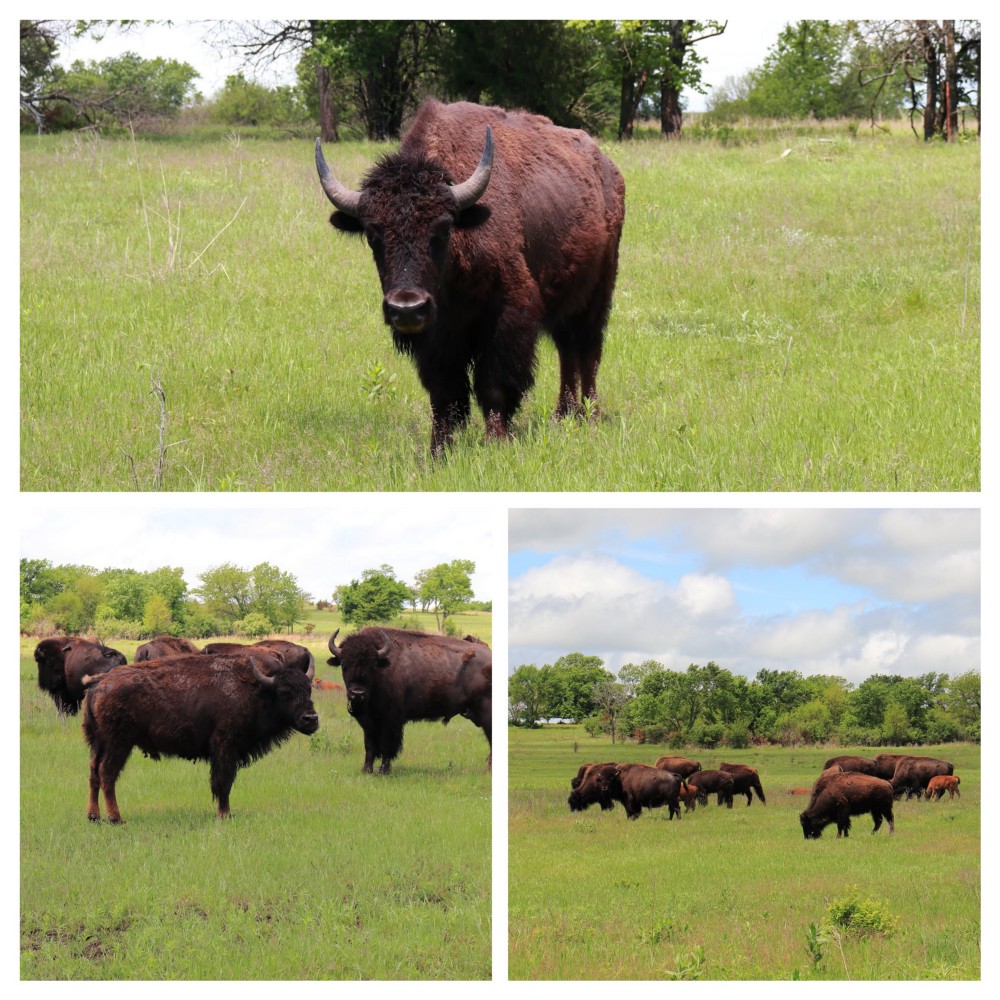
Small herd of Buffalo near Eskridge, Kansas

In no time, a herd of Buffalo stared at us in wonder at our own wonder of their sudden materializing. Most of them passively grazed without so much as noticing our existence, especially the new calves, clearly obsessed with the fresh grasses all around. An older bull and a few of the younger only glared back in obvious contempt of our ill-mannered intrusion on their breakfast.

Left: Waugh Bank Building  /  Top: Sutton Food Store (native stone) / Bottom: Tiles above Entry at Waugh Bank Building

Down the road from the great herd, Eskridge stood tall and proud, but mostly devoid of any sort of life. Unique stone architecture abounds, the significance of which did not become apparent until later at separate roadside park. It seems that most of the masonry in this region comes directly from the surrounding land.

Kansas Highway 4, west of Eskridge

Skies continued to unfold a beautiful day on the Native Stone Scenic Byway. Conversation led to one thing and then another. It was just about the time talk wandered to describing the particular circumstances typically surrounding an appearance of falls, the very topic of discussion unexpectedly materialized.

Lake Wabaunsee Falls, Kansas

A couple of hundred meters below the spillway for Lake Wabaunsee, water splashed across a limestone creek bed, dropped a meter or so and passed under the road, hurrying away for an appointment with the East Branch of Mill Creek. Very little space is afforded for parking more than one vehicle to observe this phenomenon, but traffic and general lack of population left ample opportunity for this expedition to trample the area thoroughly.

Kansas Native Stone Scenic Byway

A small rest area hosted a sign explaining the purpose of the billions of miles of stone fences witnessed along this route. Lacking basic services taken for granted in the current era, one had to do something in their free time, especially if the government was willing to pay for the rock stacking hobby.

An old homestead near Alma, Kansas

Some were inventive with their use of stone, building elegant entrances to their abode. It was too late for this homesteader though . They fenced him in and he was never heard from again.
Waterfalls at Alma City Reservoir in Kansas 

The waterfalls at the Alma Reservoir turned out a total bust. It was surprising, considering the amount of rain that had been hammering the countryside in the last week, and the earlier downpour. A few resident cottonmouths scattered in various directions on the hike down to observe the trickle of water percolating through the ground into a few murky pools of water.

Railroad Park in Alma, Kansas

Alma waited just up the road with fuel for our transport and body. On her skirts, a tiny historical park greeted passers-by with a display of abandoned properties from the glory days in the eastern Kansas prairie. All but one were shuttered tight, and the amount of dust that had settled within the millinery suggested clients were few and far between.

Mount Mitchell Heritage Prairie

A little farther up the prairie, a monument stands on a lonely hilltop once sacred to the Native Americans of this area. Captain William Mitch claimed it and the surrounding land for his own during the Kansas territory period, much to their dismay. He helped establish the Beecher Bible and Rifle Colony here. The relatively famous abolitionists from Connecticut helped stop the advancement of pro-slavery forces with support form John Brown. It is a good vantage point for such an endeavor, though they probably cooked under the summer sun of the prairie.

White Chapel School of Pottawatomie County District 51 in Wamego City Park, Kansas

The clock permitted one last brief pause for reflection in Wamego City Park. Signs of life were returning in the wake of the recent masked hysteria. The buildings remained closed, but people were out enjoying the day, and the playground no longer banned children from swinging as high as they could.


...

Further Reading

Kanza Rail-Trails Conservancy

TravelKansas.com

Mount Mitchell Heritage Prairie
MountMitchellPrairie.org

Wednesday, May 13, 2020

Blue Hole Quest

Evans Mountain Road near Appleton, Arkansas

Up Evans Mountain, across to White Oak Mountain, and down to Hurricane Creek

Winding north out of Appleton, the road quickly deteriorated, first to gravel, then packed earth, with a smattering of gravel here and there. A lonely road grader had been hard at work fixing the situation, so it proved no worse than driving on a slushy winter road.


Lush green of surrounding forest consumed the view on all sides. Enhanced by fog that increased with altitude, the scene stood reminiscent of the Great Smoky Mountains.


In this part of the world, signals are often blissfully lost for hours. A good atlas is a requirement, as road signs can be somewhat suspect, but sometimes offer just a bit more detail than the map.

Entrance to Blue Hole Road near Appleton, Arkansas

Blue Hole Road appeared quite the quagmire, having been the benefactor of so much rain the previous day. The 5 km descent to Hurricane Creek begins here, and the sloppy red clay mud quickly gave way to a relatively suitable gravel path through the forest, only occasionally rutted from prior use.

Field of poison ivy along Blue Hole Road

The cool and damp Ozark mountain air enabled movement at a decent clip. However, the finest crop of the evil Toxicodendron radicans ever witnessed deterred any thoughts of wandering off the trail.


Other less noxious species poked out the Sea of Itch only occasionally, adding some charm to the environment. Against a backdrop of the drip and trickle of water, coupled with morning birdsong, were the only signs of life.


Most of the forest bolts straight for the sky, competing for any scant touch of sunlight successful enough to pass through the thick green canopy. Some contort into odd sculptures to heighten advantage; or perhaps, simply for the sake of amusement, to pass the time. Trees can be great deceivers. Indeed, in collusion with the wind, they often trick a mind into believing one is nearer to rushing water than is actually true.

Blue Hole Cascades near Lost Corner in Arkansas


In appropriate range of the situation, the sound of water cascading across rocks and rippling down downstream is unmistakable. Arrival at the primary spectacle of waterfalls along Hurricane Creek required very little effort. The uncomplicated trail descent consumed roughly 90 minutes of relatively non-perilous foot travel.


What goes down must come up though. A continuous ascent of 5 km mocks any expecting to make the same progress as preceded their arrival, opening the 500 meters with a steep and and arduous climb out of the creek bed. The sun emerged halfway along to facilitate things, ensuring steamy conditions.

Lost Mountain, Arkansas

Surfacing from the forest, fluffy white clouds sailed from tree top to tree top against a canvas of blue skies. The journey down and back had been worth every moment, and the return to home base slipped by as quickly as the potential precipitation raced across the sky.

. . . 

Further Reading

AllTrails.com

Monday, May 11, 2020

A Misguided Attempt at Eden

AR-43 South up Gaither Mountain

Gaither Mountain to South Mountain Scenic Overlook

Detouring from the usual route south out of Harrison in Arkansas, a winding path unfolded under steel gray skies that persisted throughout the afternoon.

Left to Right — Pilot Mountain, Boat Mountain, Sulphur Mountain, Fodderstack Mountain

The meandering road over the ridge of Gaither Mountain offered very few opportunities to avert eyes from the road. However, one spot along the way demanded a pause, offering up a panoramic view of distant prominent peaks to the southeast.


Stoverville Road in Ponca in Arkansas

Ponca appeared mostly deserted on arrival, with business and usual activities shuttered against the current mass hysteria. A quick review of available maps noted nearby Eden Falls, and an effort to locate the same ensued. However, a lack of specific location data and a gravel roadway that required increasingly greater clearance, conspired against and ultimately defeated the effort.


With their glory days as wagon trails long since paved over, the roadways of Arkansas are a perfect fit for the appreciative motorist. Winding along from Steel Creek Campground on the Buffalo National Rive to Jasper is just one of thousands in the state.

Elk Statuary on the Newton County Courthouse Lawn in Arkansas

In Jasper, the clouds thinned somewhat, but refused to yield any blue sky. A few interesting distraction appeared here and there, while pausing to stretch out the road and a get a little fresh air.

1909 Newton County Jailhouse in Arkansas

The two-story Newton County Jailhouse stands mostly abandoned these days. Constructed of local stone, it served the purpose well for almost 100 years, until implementation of new villain storage space in 2009.

Chaney Log House in Jasper, Arkansas

A well-maintained representation of Arkansas pioneer homestead life moved in down the street and around the corner several years ago. After living near Osage since the mid-1800s, a few enterprising folks diligently numbered and disassembled the structure, restoring it in Jasper.

New Signage at South Mountain Scenic Overlook near Marshall, Arkansas

Upon returning to the usual route, a scenic overlook frequented along the way sported new flair. A plaque now recites the heritage of the nearby rock face, while another flaunts the fantastic view and names the site.


Friday, May 1, 2020

Coronado de Oz


Lindsborg to Wamego by way of Pillsbury Wildlife Crossing

Sunny and clear skies, along with a promised high of 25 °C, offered another opportunity to chase across the northern heart of the Flint Hills of Kansas in search of waterfalls and historical landmarks.
Interstate dominated this adventure, but only as far as Emporia. The more comfortable wide-open two lane highways unfolded through to McPherson, and north to Lindsborg.

Old Mill Bridge in Lindsborg, Kansas

“Välkommen” only to pedestrian and bicycle traffic, the 1914 iron through truss bridge leading into town stood impassable, requiring a small detour to reach the highest point of the Spanish Buttes. Allegedly, Francisco Vásquez de Coronado abandoned his search for the Seven Cities of Gold at or near this 100 meter sandstone bluff.

Coronado Heights Castle near Lindsborg, Kansas

The Works Progress Administration (WPA) honored the efforts of the Spanish explorer nearly 400 years later, constructing a small castle, complete with picnic grounds and toilet facilities. A few of the picnic sites have slumped and fallen over the course of time, but the castle stands strong and commands quite a view of the surrounding prairie.

Google Maps view of I-70 Exit 316

Back to the Interstate and, pavement abruptly ended at the exit for the Deep Creek area, 100 km to the east. There was no notice of termination of said situation, which presented quite the surprise at 120 kmh. However, a few more pleasant surprises appeared in reparation of the induced anxiety.

Deep Creek Schoolhouse near Pillsbury Crossing, Kansas

Deep Creek School stands sentinel along what was once a historic trade route between the Pawnee and Wichita tribes. Their graves remain unmarked and undisturbed since the first settlers arrived in the region. This third rendition, built in 1892 of native sandstone, now serves as community center for the area it once educated.


Chris Barr’s Cabin near Pillsbury Crossing in Kansas

One such resident might have hailed from Chris Barr’s cabin, a short distance down the road, built sometime before 1863. Discovered inside of another house torn that was torn down in 1962, it had chose to conceal its identity, after spending so much time as a station along the underground railroad.

Pillsbury Crossing Wildlife Area in Kansas
The primary attraction for settlers to this particular area was very likely the fresh flowing water of the cascade at Pillsbury Crossing. The falls continue to attract a variety of wildlife, often seen cavorting in the cool waters.

Oz Oddities in Wamego, Kansas

A thirst for gasoline enabled a minor moment of discovery regarding the land of Oz. The Yellow Brick Road seemed a lot wider and longer in the movie.

Old Dutch Mill in Wamego, Kansas

Emerald City appears quite different too, having apparently expanded into more diverse industrial ventures. The 1879 windmill relocated here in 1925 from approximately seven kilometres north, being taken apart and reassembled numerically by one who enjoyed puzzles more than most.

Top: 1885 Cottonwood Dist No 11 Schoolhouse / Bottom: 1898 Hinerville Schoolhouse

One might say that early Kansans had a great affinity for stone. This region provided plenty of stock for their exploits. Nowhere is it more evident than in the schoolhouses that litter this particular region. Two more suggested a documentary pause, before the return to the Interstate homeward.


...

Further Reading

Old Mill Bridge
BridgeHunter.com

Coronado Heights
Smoky Valley Historical Association
Kansas Wildlife, Parks & Tourism

Old Dutch Mill
Wamego Historical Society & Museum

Popular Variations