Showing posts with label trails. Show all posts

Friday, May 23, 2025

Lake Morning Platte Hikes


Enjoyed an opportunity to escape the drudgery for a couple of hours this morning and take a look at a couple of trails that I had not yet seen.  A beautiful sunny and crisp 15° C morning found the first, Green Hills of Platte Wildlife Preserve, generally okay. Half of the trail was mostly a wide gravel path, with the second half of the trail winding through a dense forest and a collection of poison ivy and ticks, within earshot of passing traffic.  I emerged unscathed and will probably have another look here once everything dies again.

The second trail was one that I had driven by several times, though had not had a chance to stop, being urgently on my way to another destination.  Charlotte Sawyers Nature Area offered a better opportunity to get away from civilization.  Voices from a neighboring farm could be heard along with random air traffic and that was about it.  It was little more than a mowed path around an overgrown field but served the purpose.  It offered space for quiet contemplation.

Wednesday, December 27, 2023

Endangered Hell Creek


Emerging quietly from a natural spring in an obscure hillside, a small stream scours a path through the surrounding oak and hickory forest on the outskirts of Mountain View. Here, within the boundaries of Hell Creek Natural Area an endangered space offers refuge for the endangered, in one of the few surviving examples of the original natural landscape.


One would be lucky to have found a trail into this location at all, just a few short years ago. Most passers-by would have simply overlooked the mostly unimpressive branch trickling beneath a hairpin curve on Mountain Crest Road. Even with a recently installed parking area and signage at the end of Sarah’s Way, one still has to know what to look for. There is no official trail.


The most generally accepted track down to Hell Creek cuts a deer path through the forest, northeasterly from the parking area. Half-way down the slope an old fire road intersects requiring minor reconnaissance to pick up the trail again. It eventually opens up a hundred or so meters later, offering two potential directions for exploration, both easily accomplished together in under an hour. However, that is hardly sufficient time to enjoy this distraction.


A choice in either direction unfolds an excellent display of the sort of solution weathering continually reshaping most of the Ozarks over the past million or so years. Minor caves, karst monoliths, and rock bridges, litter the banks and bed of the creek.


In the winter environment of this observation, water appeared as book ends on the formation. It suggests a persistent solution channel silently at work beneath and between the rock layers, in spite of the dryness of this season. Various reports identify water as much more apparent during the wet season, evidenced through the variety of formations on location.


Hiking upstream along the trail, towards the previously mentioned hairpin curve, then returning along the same path, enables a better view of the transition downstream. Soft and muddy root entangled banks slowly give way to slabs of rock beneath and flanking the channel. Stepping down gradually, digging in a little deeper as it moves along, the creek relentlessly bores through everything in its path.


The stream eventually spills onto private land a little less than a kilometer north of the trail intersect, derailing any effort to continue downstream to the White River. While the path is not obstructed, forging ahead could be dangerous. Best practice urges respect for posted boundaries.


Ensure an equal level of regard for the wildlife here too. The site offers refuge to more than just dwindling numbers of the gray bat (Myotis grisescens). A namesake creature known as the Hell Creek Cave Crayfish (Cambarus zophonastes) also makes home here. Both are listed as endangered species.


Hell Creek Natural Area appears equally endangered for Arkansas. Human disturbance and environmental contamination top the list of impending dangers to the wildlife and the area. Indeed, this particular visit noted visible trash and accelerated development in the surrounding area.

Sincere efforts toward protecting the site began in in 1985, when Arkansas Natural Heritage Commission acquired the land. In a partnership with the Cave Research Foundation, the groups continue efforts toward a more thorough inventory of this unique and imperiled ecosystem.

These actions often come as blessing and curse though. The more intriguing a site for both science and citizen, the more it becomes trampled, quickly losing any sense of the natural.

. . .

further reading

Hell Creek Natural Area
Arkansas Heritage

Arkansas scoured for hidden caves and secrets within
Arkansas Democrat Gazette

Gray Bat (Myotis grisescens)
U.S. Fish & Wildlife Service

Hell Creek Cave Crayfish (Cambarus zophonastes)
U.S. Fish & Wildlife Service

Friday, November 10, 2023

Chinquapin Trail


Excepting the random cry from resident avian species, quiet reigns under clear blue 18 ºC November skies, at Big Sugar Creek State Park and the Elk River Hills Wild Area, in southwest Missouri.


One can be alone with their thoughts in this space, allowing them to drift, gently tethered, similar to the wild oats along the banks of now dry creeks, swaying back and forth on the whims of the breeze. Not another sound intrudes on the scene, excepting the steady crunch of leaves underfoot, and their occasional rustling from above.


Small bits of water remaining are crystal clear, reflecting the mostly naked upper story of this hardwood forest. Ferns cling to life along the creek banks too, keeping warm under a sun normally much too scorching. A few young oaks blaze red, and an occasional maple shines yellow; all else is deeply bronzed or brown. An offhand breeze rises, falling off as quickly, causing leaves to occasionally shower lightly down.

Packed earth, littered with small gravel is interrupted by layered rock beds spanning the multiple creek crossings. Outcrops of rock across the hollow suggest an ancient cover collapse incident throughout the area. Water has been at work here for a very long time, shaping and reshaping the landscape. While mostly dry on this date, it is evident that the rainy season hosts an entirely different landscape.

Rising to the highest point along the trail, the stench of nearby pig farm drifts into range. The pungent odor is as quickly lifted away by a soft breeze reaching the crest of this Ozark ridge at the same moment.


Descent in the second half is only somewhat different, hosting much larger obstacles along the path, which hide under a thick blanket of leaves. It is wiser to pause to take in a view of the deepening hollow below, than take the chance of stumbling on one of the numerous complications underfoot.


This stream bed displays evidence of water flowing and pushing through the landscape with increased determination in this section. Indeed, the tour could be quite treacherous in the Spring, potentially unpassable. Snarls of trees remain piled up in places from the last deluge, and further along, gouged banks snake through, revealing a soil profile unsuitable for much of anything.


While water is in more abundance, it still only stands in pools or trickles along, though sounding much more dramatic than on the other side of the ridge, in the persistent silence. A small rock rolling down the hillside, at first, sounds a boulder crashing through the landscape.


Soaking in the last mile at a slower pace, one creek crashes into another, mingling and running in different directions. Surrounding rock bluffs and the beds are more sculpted, and small hollows offer up winter homes to various critters of the region.


Rising up along a small bluff, then descending again, leads to yet another seasonal stream merging with another. The glade from which this journey began is not far beyond that. Voices drift lightly down from above. It is the first sign of humanity in nearly two hours, at once dreadful and enabling an odd sense of reassurance at the same time.

. . .

further reading

Big Sugar Creek State Park
Missouri State Parks

Elk River Breaks Woodland
Missouri Department of Conservation

Tuesday, July 6, 2021

Newline Creek Trail Sawmill


Nathaniel Herrick dreamed of forging a life for his family in the mountains of central Colorado. Working hard to achieve that goal, it slipped from his dying fingers the same year he got started. The Newline Creek Trail follows the path of his work to the site of his ambition, though very little evidence remains.


In 1887, Coal and silver mining camps littered the landscape of Colorado and companies running these operations needed timber for various construction efforts. Nathaniel saw an opportunity, deciding he could provide for those companies and, at the same time, his family.

Signing a chattel mortgage for nine hundred dollars in 1887, he set out to purchase equipment and tools needed to get his business off the ground. Horses, mules, a couple of log wagons, and a Studebaker wagon with log chains were included in the inventory.


Under the shadow of a ridge near Stull Mountain, Nathaniel began setting up the planned timber harvesting and milling operation. A place to live and work was cleared about 4 kilometres up Newline Creek; all that remained to do, clearing and grading a wagon road up to the location.

Hard labor built a path wide enough to transport essential operating equipment to the site more than 500 meters up from the valley floor. It also served as a clear and reliable path for the return of manufactured materials from the sawmill back down the mountain.


Equipment moved to the site included a fairly large steam boiler and flywheel, manufactured by the Great Western Foundry of Leavenworth. Cradled by brick and stone walls running the length of the boiler, it would be the backbone of the operation.

Not long after getting all of this in place and beginning operations, Nathaniel died in the same year he began work on the project. Leaving a wife and children unable to continue his work, the forest reclaimed the land.


This section of the San Isabel Forest in the Wet Mountains now hosts Newlin Creek Trail, which wanders along some of the original path Nathaniel cleared 134 years ago. Until reaching the mill site, evidence of his hard work and determination are hardly visible though.


The 4 kilometre trail begins somewhat sandy. It gradually changes to courser material from the surrounding area, packed earth in other places, with a few rocky spots sprinkled in along the way. Most of the length is shaded by massive pines and surrounded by sometimes even larger granite structures that solidified nearly two billion years ago.


Granite is important part of the landscape in this valley and along the creek, where it constantly recreates the series of small cascades running the length of the creek. The pools are not deep though, and the numerous crossings usually have some sort of structure enabling passage. There is one constructed bridge at the first crossing. All of the others are improvised.


The trail leads directly to the installation site of the boiler, and where it remains, rusting and perched upon a crumbling stone and brick cradle. Scattered around the boiler, parts hide in the brush and mountain wildflowers, slowly rusting into the landscape. The fireplace from the cabin also stands just a short distance away, as well as some milled boards.


The path continues beyond the mill site, through denser brush, to a large granite outcrop near the top of the ridge. The trail becomes obscured in this area. An outcrop offers an excellent view of the treetops in the valley, with nearby ridges in the distance, and lacking maps, good place to turn around.


Accessing the site passes by Florence Mountain Park and at the end of County Road 15 in Fremont County. Flash flooding is a concern in this area during sudden rainstorms. The road contains deep gouges and is likely impassable during wet conditions, except to vehicles appropriate to that sort of situation.

. . .

further reading

US National Forest Service

Colorado Central Magazine

Find A Grave Memorial

Spanish Peaks County

Saturday, September 5, 2020

Arkansas Indian Rock Cave


During the early the 20th century, museums and archaeologists were running amock, digging up half the country for relocation to their dusty warehouse bins on the east coast. One Samual Dellinger, a trained zoologist was not impressed. He recognized the value of archaeology in the Arkansas region and began a program of excavations of Ozark bluff shelters in the 1930’s to preserve and protect discoveries in the state for further study. Much of his work endures today.


One such site lay near the town of Edgemont, just east of what is now Fairfield Bay. Eerie and impressive geologic features litter the landscape in this area, coupled with equally interesting rock art at what has been dubbed “Indian Rock Cave” or “Indian Rock House.” Formally known as the Edgemont Shelter, it is attached to a local golf course and consequently, one of the most accessible of the bluff shelters in the state.


The starting point for the trek down to the shelter is a small museum within a reconstructed log cabin, which interprets the shelter and early historic settlement in the region. It hosts a variety of artifacts found on site, to include a few items from late-period Native American occupation of the region.


A brief descent along wooden stairs leading from the museum opens on to a relatively well-maintained track for a few hundred meters. It quickly opens on a clearing where the dominant feature is that of the shelter. A 1934 plaque installed by the Daughters of the American Colonists declares proudly that Hernando De Soto once visited this site. Although, more current understanding of the route of that particular explorer denies the probability.


Native Americans used the site at various times during the past 8,000 years. That much is certain, as evidenced by petroglyphs carved into the rock face. Very little else is known about the true archaeology of the site though. It was never professionally excavated, and the only known artifacts were collected by amateurs during operation of the site as a tourist destination in the 1930’s. Later in the 1960’s, a backhoe removed about six feet of dirt, further complicating efforts to comprehend anything that might have occurred at this location.


The shelter is not the only thing of interest in this neck of the woods though. The remainder of the 1.2 km journey through the surrounding hardwoods around the bluff and is equally intriguing. Cracks and crevices abound and beg exploration from multiple angles. It is a veritable playground of karst features at nearly every turn. What one first considers a brief hike to a natural wonder quickly and quietly expands into an exploration of a strange and wonderful crumbling world in the heart of the little resort community of Fairfield Bay.

. . .

further reading

Indian Rock Cave or Edgemont Shelter at Fairfield Bay
Bluff Shelters of the Arkansas Ozarks

Thursday, August 6, 2020

Devil’s Roaring River Kitchen


A beautiful day unfurled for an expedition to a familiar pause along the regular trail south. Proper reconnaissance of the situation aided immensely in arriving quickly, allowing more than enough time to enjoy the geologically contemplative 2.4 kilometre walk through the Devil’s Kitchen at Roaring River State Park.


The map made available locally lacked much detail beyond the trail outline. Undeterred, a couple just then leaving indicated the best route to be along the right fork, saving the prize for last. Trail markings were not quite what they could have been, expediting arrival at another trailhead along the west bank of Roaring River. Doubling back to a previously noted fork, another passing couple confirmed the misstep.


Having completed their journey, they offered a much better map they had obtained from a different source. While the trail map itself was equally as uninformative, it did contain a guide to all of the notable features along the way. The intended exploit into the Devil’s Kitchen suddenly became much more educated.


The first stop along the way is known as “The Bench.” This contact zone between the dolomite and limestone lurks in the background through much of the stroll, here surrounded by oak and hickory.


Small shelter caves are scattered everywhere near the second signpost. 15 of the 20 of the structures within the park are found along the bench. Bluff-dwelling tribe from 10,000 years ago once called this home and safety from the elements.


Only meters away at the third station, the living Lignite Cave carves a joint into the rock for 10 meters before narrowing to only 10 centimetres. A chimney at the back of the cave completes the abode, but buyer beware, water travels that path during heavy spring rain and extensive wet periods.


Above the bench in a dry chert woodland, the trail through marker 4 is much like walking through ground glass. The flint-like material litters the trail and surrounding landscape, hosting Ozark Chinquapin, Farkleberry, and an assortment of other undergrowth pushing up from the layers of chert.


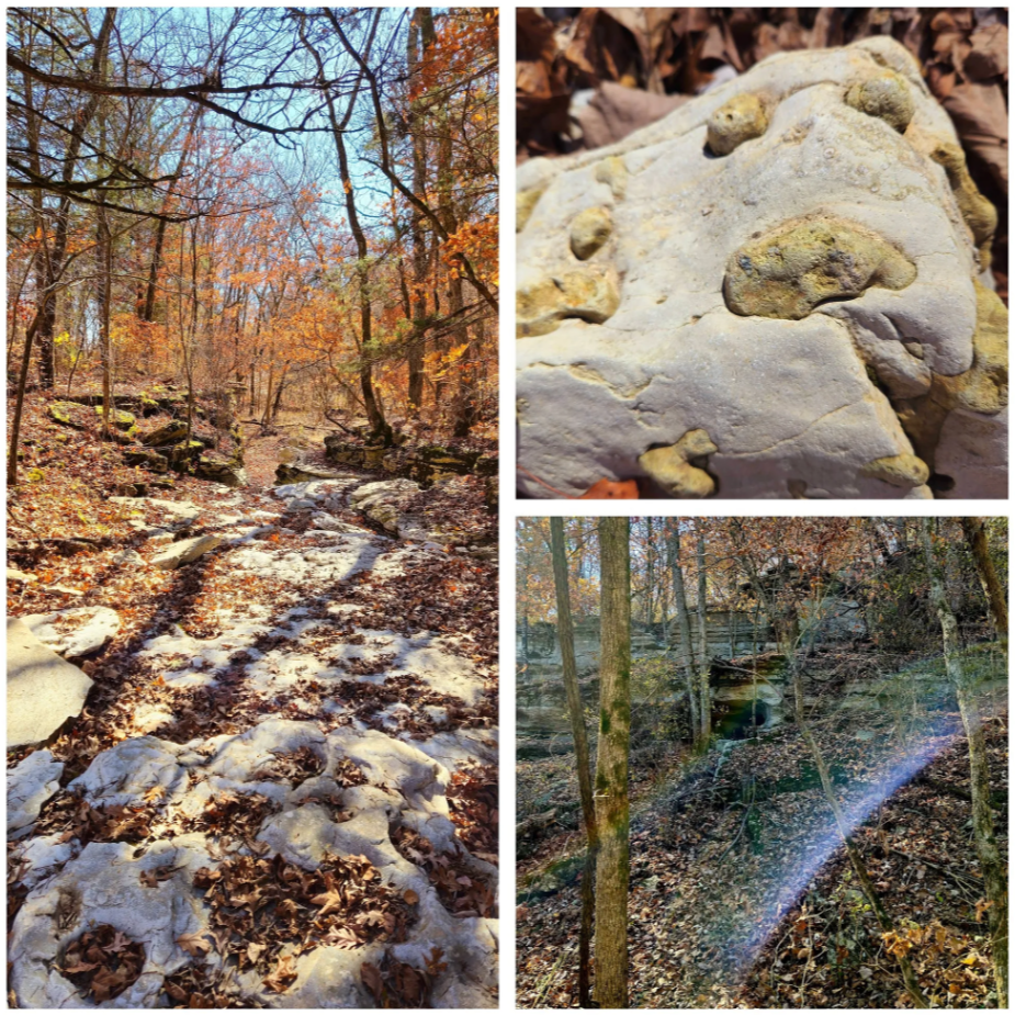
Near the top of the ridge, several outcroppings of the sedimentary rock, layered into the limestone, are available for review along the way. In the late summer foliage, very little is visible though without a detour off the main trail.


Nearly 100 meters above the trailhead, the ridge finally tops out at a massive 414 meters above sea level. A pine woodland lies below with some trees in the grove estimated at over 225 years in age. Conditions on this south-facing slope are relatively favorable to them, with regular intense sunlight and the chert filled, acidic soil. The trail cuts back through the bench in this part, and the pines fade into Eastern red cedars, peppered with farckleberry and blueberry.


Along the way, a small spring carves a new cavity in the soft sandwich of Chattanooga shale layered between limestone and dolomite. It is much to small to explore for anyone other than the grotto salamander and likely the sustenance it requires, the cave cricket, among others.


The bench suddenly becomes broken and shattered here and there, seemingly in a slow-motion tumble. Soft layers of shale within the rock keep things moving along at a fairly quick geologic pace, but to stand and watch in real time could mean death by boredom.


Evidence of this appears at the final station, Devil’s Kitchen. The massive rock falling at every angle began moving hundreds of years ago, creating a small shelter in the massive boulders. Legend says Civil War guerrillas leverage the spot for one nefarious purpose or another. It well they did not use it for long. The roof of the kitchen collapsed in 1985, and again in 2001, sealing off back entrance to the kitchen.


Red cedar, chinquapin, oaks, and blue ash escort the remainder of the way, offering up an exhibit of an array of weathering and erosion effects. While typical of much of this region and the Ozark plateau, as with any sort of karst topography, it is unique environment to this specific location.


. . .

further reading

Missouri State Parks

Missouri Department of Conservation

Missouri State University

Saturday, May 16, 2020

Faces at Cave Hollow Park


Very little has changed at Cave Hollow Park over the past million or so years. Erosion continues the slow and steady work it set out to accomplish. Trees live and die. People come and go. Some changes appear long-lived, but most in the last century are but a blink in the eye of the geology timeline.


Little is known about the prehistoric history of the park. It is first noted as far back as 1880, when the Grand Army of the Republic set up the Colonel Grover Post nearby. The location quickly became a popular spot for adventurers, young lovers and later, more commercial enterprises. A spring supplied water for the old town of Warrensburg, and later a hospital leveraged the space for a “pest house” to rid themselves of those plagued by Small Pox. Then it filled with trash as a dumping ground. It returned as a playground sometime in the 1970s, after increasing pressure from the community.


Accessing the park is easy enough, but finding the trail that leads to the more interesting aspects requires some insider knowledge; or only a little poking around. A partially hidden paved path next to the playground leads into a deep wooded ravine. Various branches split off in different directions, most of which led nowhere.


One diversion offers a glimpse of a massive rock shelter cave, visible from the main path, similar in scope and size to that at Graham Cave State Park. This one seems a bit larger, though not as deep. A few more digressions on either end of the structure lead to the top, and smaller adjacent, shallow caves.


The main paved path abruptly ends at a park bench shortly thereafter. At first glance, it appears to open only on a small hollow, containing several smaller rock shelter caves. Closer inspection reveals other oddities.


A face or two, animals, names and symbols appear etched in the rock at every turn, along with more modern painted additions, decidedly less attractive and equally abundant. These petroglyphs seem as though they could have been chiseled by some long-forgotten tribe, but are of unknown, somewhat modern origin. It is a tradition understood to traverse the history of the space, and an intriguing display of the desire of man to be remembered.


The brief 300-meter ramble through this wooded geologic time capsule is peaceful, beguiling, and thought-provoking. It is difficult to imagine this place as anything other than it is now, much less the dumping ground it was throughout half of the 20th century.


Certain individuals have not entirely given up on the effort either, in spite of years of citizenry calling for restoration of this environment. At the opposite end of the park, not all that far away, space appears used for disposal of a variety of waste products. It is likely the most surprising aspect of the situation, since run-off could easily poison either stream or cave structure.

. . .

further reading

Google Books


Popular Variations