Saturday, March 21, 2020

Spring Break Evacuation

Building mural in Tonganoxie, Kansas

Roaming the region around Kansas City at a safe social distance

Plans for wandering about this past week went awry with the increasing popularity of COVID-19. While cases in areas considered for travel remained very low, and planned public contact extremely limited, it seemed better to err on the side of caution and explore other options.

In all fairness, the virus was not the only barrier. A week long forecast filled with cool temperatures, gloomy days, and endless rain seemed to envelop the entire country. The cards simply were not stacked favorably.

Researching meteorological and contamination conditions on the ground of potential spots within striking distance, a few interesting places offered a chance for a somewhat dry and healthy escape.


The first day out was the longest trek, a 160 km journey to Locust Creek Covered Bridge State Historic Site in north-central Missouri.  Accessing the site was easy enough, though could be challenging under wetter conditions. A narrow foot bridge crosses Locust Creek from the parking area and connects with the old road leading to the covered bridge. Rain from preceding days had created a quagmire for about 20 meters from the foot bridge to the raised bed of the old road leading to the covered bridge.

Locust Creek Covered Bridge

The old white pine bridge is mostly unremarkable in appearance, but is the longest of four remaining covered bridges in Missouri, measuring 46 meters. Locust Creek no longer passes beneath it quite as often as when originally constructed in 1868 for use as a crucial link within the transcontinental roadways of the nation.

War Angel sculpture at Pershing State Park

Only 18 km further down the road, Pershing State Park begged investigation too. Honoring General John J Pershing of World War I, who apparently spent his boyhood playing and hiking in the area, the park offers immersion in the wetland landscape surrounding Locust Creek.


Another bridge of an unknown era crosses into the wetlands, coupled with a boardwalk trail meandering through. With rain stirring and time waning, the acquaintance was set aside for another occasion.


The rain dissipated as quickly as it had appeared, of course. It was really no matter. The brief outing had been good. Wandering the back highways towards home base offered time for peaceful reflection, and occasion to meet Maxine, the “World’s Largest Goose.”


. . . 

After some minor preparations for the coming viral apocalypse, some time was set aside time the following day to locate a waterfall only 50 km down the road over in Kansas. That the relatively flat state has anything beyond man-made falls remains a point of curiosity and intrigue.

Angel Falls in Lansing, Kansas

Angel Falls is easy to find and even easier to access. A short ½ km paved path behind St Francis de Sales Catholic Church in Lansing leads to a footbridge crossing Sevenmile Creek. The one meter falls are immediately visible from the bridge or after crossing, a short packed earth path leads directly to the base of the falls.

The trail must be a fairly popular destination. Even on this cold and gloomy day in the small town of Lansing, several were out and about walking dogs or just passing through. We kept our distance, and they theirs, quickly departing before the population exploded.

Riverside Falls in Riverside, Missouri

Choosing an alternative route home, a momentary pause in Riverside for a look at their falls ended a relatively low-key day.


. . . 

Warm sunshine filled the following day, and the temperature soared to about 24°C amid increasing clouds. Certain obligations prevented much wandering about, but a short hike close to home rounded out the day nicely.

Pond and wetlands near KCPD Trail of Heroes

The relatively new, and still somewhat incomplete, KCPD Trail of Heroes strolls through nearby wetlands of Shoal Creek and features memorials to various police officials in the history of Kansas City. Recent rainfall washed out part of the 1.2 km trail, but it remained manageable.

. . . 

Building mural in De Soto, Kansas

Skies were clear and sunny again the following day, but the temperature had dropped significantly to a cool 7°C. Undeterred, some time was spent simply wandering back roads to a point just southwest of Lawrence, Kansas. What is normally only a one-hour trek, took just over 2 hours.

Wilkey Waterfalls near Lawrence, Kansas

Situated on the Wakarusa River below Clinton Lake Dam, Wilkey Waterfall is about 2 meters tall. The falls are not much more impressive than those in Lansing, but scenic in their own unique way, as most are. Viewing them is not possible from anywhere but beside them, and it can be a somewhat perilous journey down a steep riverbank to do so, depending upon conditions. Lots make the journey for other reasons though. It is seemingly a popular little fishing hole.

Congregational Church in Tonganoxie, Kansas

The return trip was uneventful, and not quite as time-consuming as the trip out, but a ice drive under beautiful blue skies, windows down, music up.


. . .

Intending to remain at home base and continue preparations for the coming viral apocalypse, partly sunny skies and slightly warmer temperatures urged further wandering about.

Captain Creek Waterfall

Another set of waterfalls lying just south of Eudora in Kansas were proved a tiny bit trickier to locate. The first attempt was a bust, having transcribed coordinates incorrectly. Turning back down the road a couple of kilometers to pick up a mobile signal again, the error turned out minor. The presumed location of the falls were only a kilometer east of where originally marked.

Captain Creek Waterfall

Arriving at the corrected location, accessing Captain Creek Falls required only a bit more effort. Traipsing about 400 meters along the associated creek and the boundary of a farm field, the sound of rushing water soon filled the air. They turned out no more impressive than those visited earlier in the week, but they had been located. Mission accomplished.


Monday, November 11, 2019

Arkansas Video Adventuring in November

Southbound on County Highway Z near Branson

November is one of the best times to visit Arkansas.  I continue to explore the potential of displaying photography associated with the journey down and back using video.

The road passed south through Missouri, branching off into the back roads from Fordland through Willhoit.

Crossing the state line, a nice place to pause was found at Pigeon Creek, before journeying on to Norfork.

A few days were spent wandering about Greers Ferry Lake area, to include Mossy Bluff National Nature Trail, Bridal Veil Falls, Big Creek Natural Area, as well as Blanchard Springs.

Snow blanketed the roadways on the journey home, with colder than necessary temperatures preventing any further exploring.


Saturday, October 19, 2019

Colorado Video Adventuring through Kansas

Kansas State Highway 50, west of Elmdale
Loosely following the Santa Fe Trail out of Kansas City, clear skies, warming temperatures, and empty roads provided the perfect backdrop for an 8-day, 2400 km journey across Kansas into Colorado and back.


Sites included Pawnee Rock State Historic Site, Fort Larned National Historic Site, Santa Fe Trail Tracks site, Bent's Old Fort National Historic Site,  rummaging around old Florence, along the Arkansas Headwaters Recreation Area, Brown's Creek Trail, St Elmo ghost town, Temple Canyon, Historic Arkansas Riverwalk, Little Jerusalem  State Park, and Monument Rocks National Historic Landmark, and a various points in between.

All were captured on film and transferred to video in a continuing venture into documenting these adventures in that format. Not all photos were included in the video above, on a few sites.  They were separated into individual feature films below.


Saturday, September 7, 2019

Thomas Hart Benton Home & Studio State Historic Site


Undoubtedly the most renowned artist from Missouri, Mr. Benton possessed a unique ability to interpret American lifestyle and culture, unmistakable and somewhat a matter of state pride. On permanent display in House Lounge of the Missouri State Capitol, A Social History of the State of Missouri stands testament to his accomplishments. The mural is a marvel in real time.


Excepting large scale installations like those, he worked primarily from his home in the Roanoke area of Kansas City, from 1939 until his death in 1975. Preserved as Thomas Hart Benton Home and Studio State Historic Site, entering the home is as if he only just stepped away.


The house reflects the varied interests of the artist and his family, containing many of his favorite original paintings and sculptures, and gifts from others.


The converted art studio in the carriage house remains much as he left it. A scattering of jars and and cans full of paintbrushes, paint, and a lone canvas standing in the sunlight awaits his brush.


Indeed, Mr. Benton had just put the final touches on The Sources of Country Music, a mural painted for the Country Music Hall of Fame in Nashville, immediately before his death.


This site is one of the few gems in the city of Kansas City as times slides on but is well worth the visit. The following video gives a small taste of what this state park has to offer.


. . .

further reading

Missouri State Parks

Monday, September 2, 2019

Northern Corridor 13

Entrance Road to Crowder State Park

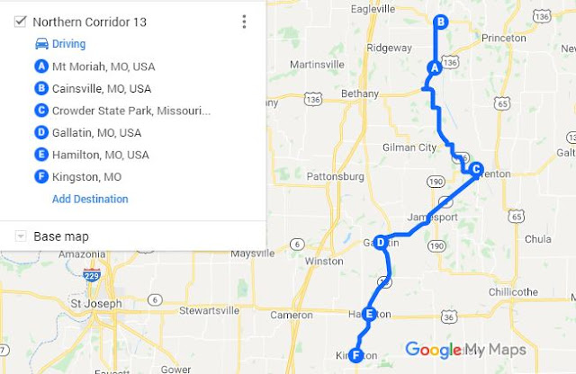
Wandering to, through, and beyond Crowder State Park along Missouri Highway 13

One could not have asked for a better day to wander the rural quadrant of eastern northwest Missouri. Skies started off clear, and the cool 24°C of the morning certified it as the perfect chance outing.  Weather transitioned along the path northward though, as Cumulus slowly began closing out the sun. The edges of a storm raging in eastern Nebraska were slowly reaching into the area.  A small town where a friend spends most of his free time appeared along the way, a quick visit seemed in order, and the adventure began.

Farmers Exchange Building — Mt Moriah, MO

Mt Moriah, established about 1867, sits on the west side of the Thompson River floodplain northwest of US-136. It appears to have been a tight knit little community, and likely still is, though probably not quite as populated.  A lack of phone service prevented visiting though. I spoke with some local folks that held the same last name. They explained how to get to his place, but something got lost in the translation and the quest was abandoned.

Stoklasa Memorial Chapel — Cainsville, MO

A little further down the road, Cainsville appeared under sunnier skies. Originally the site of a watermill in 1854, it is not a particularly remarkable town. There are a few interesting structures, but is a mirror of the many mostly abandoned rural towns in this part of Missouri. Ancestors lived there once upon a time, in the late 1800s, and the family farm still hosts some descendants. Harassing distant relations unannounced seemed improper though, and hiking awaited at Crowder State Park.


The day had only warmed a couple of degrees °C from its start, and with clearing skies, Tall Oaks Trail enabled a round of contemplation. A return trip in early spring or fall may be in order, when the population of insects is not quite so lively.
Tall Oaks Trail at Crowder State Park

With the afternoon waning, the road unfolded again. Navigation indicated it would only take a few hours to traverse the 140 or so kilometers back to base, if you followed the suggested route. Paper maps and intuition would lead the way from here though.

Daviess County Courthouse — Gallatin, MO

Gallatin was the next town down the blacktop. On this occasion, the streets and courthouse stood mostly quiet. Multiple flags flapped in the breeze, as a 3-inch ordinance rifle from the Civil War stood guard.

Map by John Hamer [CC BY-SA 2.5]

Founded in 1837, it was the site of an election day battle a year later. Latter-day Saints burned and looted this and other nearby towns, in conflict over their right to vote, and as part of a larger confrontation raging at the time.


Turning south, Hamilton appeared next. It owes existence largely to the railroad. The Hamilton Town Company formed to develop a tract of unsettled prairie belonging to the US Government in 1854, right along the rails of the Hannibal & St. Joseph Railroad.

Inside the J.C. Penny Boyhood Home — Hamilton, MO

Come to find out, it is also the boyhood home of businessman and entrepreneur, J.C. Penny. The house in which he spent his youth is a showcase of how things appeared at that time of his life. It is not the original location, but a bit more prominent place on the main drag of town.

Caldwell County Courthouse, Missouri

Kingston lay just a little further south, nominating itself as the last stop of the day. Laid out in 1843 to replace Far West, as seat of Caldwell county, it is mostly remarkable. The courthouse, silent and empty on this Labor Day, while a block long row of buildings from a more prosperous era sag and decay across the street.


More photos from the Journey


. . .

Further Reading
Missouri Secretary of State


Popular Variations