November is one of the best times to visit Arkansas. I continue to explore the potential of displaying photography associated with the journey down and back using video.
The road passed south through Missouri, branching off into the back roads from Fordland through Willhoit.
Crossing the state line, a nice place to pause was found at Pigeon Creek, before journeying on to Norfork.
A few days were spent wandering about Greers Ferry Lake area, to include Mossy Bluff National Nature Trail, Bridal Veil Falls, Big Creek Natural Area, as well as Blanchard Springs.
Snow blanketed the roadways on the journey home, with colder than necessary temperatures preventing any further exploring.
Loosely following the Santa Fe Trail out of Kansas City, clear skies, warming temperatures, and empty roads provided the perfect backdrop for an 8-day, 2400 km journey across Kansas into Colorado and back.
Sites included Pawnee Rock State Historic Site, Fort Larned National Historic Site, Santa Fe Trail Tracks site, Bent's Old Fort National Historic Site, rummaging around old Florence, along the Arkansas Headwaters Recreation Area, Brown's Creek Trail, St Elmo ghost town, Temple Canyon, Historic Arkansas Riverwalk, Little Jerusalem State Park, and Monument Rocks National Historic Landmark, and a various points in between.
All were captured on film and transferred to video in a continuing venture into documenting these adventures in that format. Not all photos were included in the video above, on a few sites. They were separated into individual feature films below.
Undoubtedly the most renowned artist from Missouri, Mr. Benton possessed a
unique ability to interpret American lifestyle and culture, unmistakable and
somewhat a matter of state pride. On permanent display in House Lounge of the
Missouri State Capitol, A Social History of the State of Missouri stands
testament to his accomplishments. The mural is a marvel in real time.
Excepting large scale installations like those, he worked primarily from
his home in the Roanoke area of Kansas City, from 1939 until his death in 1975.
Preserved as Thomas Hart Benton Home and Studio State Historic Site, entering
the home is as if he only just stepped away.
The house reflects the varied interests of the artist and his family,
containing many of his favorite original paintings and sculptures, and gifts
from others.
The converted art studio in the carriage house remains much as he left it.
A scattering of jars and and cans full of paintbrushes, paint, and a lone canvas
standing in the sunlight awaits his brush.
Indeed, Mr. Benton had just put the final touches on The Sources of
Country Music, a mural painted for the Country Music Hall of Fame in Nashville,
immediately before his death.
This site is one of the few gems in the city of Kansas City as times
slides on but is well worth the visit. The following video gives a small taste
of what this state park has to offer.
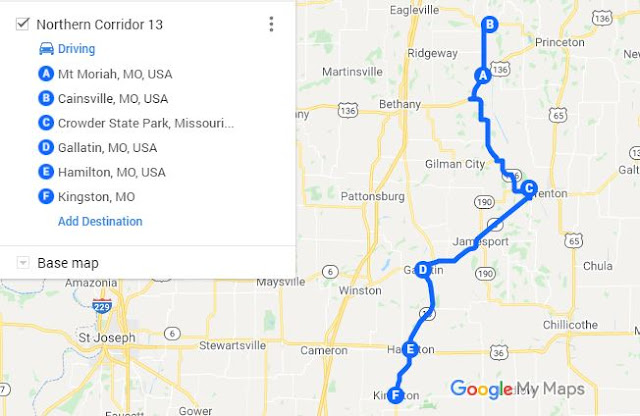
Wandering to, through, and beyond Crowder State Park along Missouri Highway 13
One could not have asked for a better day to wander the rural quadrant of eastern northwest Missouri. Skies started off clear, and the cool 24°C of the morning certified it as the perfect chance outing. Weather transitioned along the path northward though, as Cumulus slowly began closing out the sun. The edges of a storm raging in eastern Nebraska were slowly reaching into the area. A small town where a friend spends most of his free time appeared along the way, a quick visit seemed in order, and the adventure began.
Farmers Exchange Building — Mt Moriah, MO
Mt Moriah, established about 1867, sits on the west side of the Thompson River floodplain northwest of US-136. It appears to have been a tight knit little community, and likely still is, though probably not quite as populated. A lack of phone service prevented visiting though. I spoke with some local folks that held the same last name. They explained how to get to his place, but something got lost in the translation and the quest was abandoned.
Stoklasa Memorial Chapel — Cainsville, MO
A little further down the road, Cainsville appeared under sunnier skies. Originally the site of a watermill in 1854, it is not a particularly remarkable town. There are a few interesting structures, but is a mirror of the many mostly abandoned rural towns in this part of Missouri. Ancestors lived there once upon a time, in the late 1800s, and the family farm still hosts some descendants. Harassing distant relations unannounced seemed improper though, and hiking awaited at Crowder State Park.
The day had only warmed a couple of degrees °C from its start, and with clearing skies, Tall Oaks Trail enabled a round of contemplation. A return trip in early spring or fall may be in order, when the population of insects is not quite so lively.
Tall Oaks Trail at Crowder State Park
With the afternoon waning, the road unfolded again. Navigation indicated it would only take a few hours to traverse the 140 or so kilometers back to base, if you followed the suggested route. Paper maps and intuition would lead the way from here though.
Daviess County Courthouse — Gallatin, MO
Gallatin was the next town down the blacktop. On this occasion, the streets and courthouse stood mostly quiet. Multiple flags flapped in the breeze, as a 3-inch ordinance rifle from the Civil War stood guard.
Founded in 1837, it was the site of an election day battle a year later. Latter-day Saints burned and looted this and other nearby towns, in conflict over their right to vote, and as part of a larger confrontation raging at the time.
Turning south, Hamilton appeared next. It owes existence largely to the railroad. The Hamilton Town Company formed to develop a tract of unsettled prairie belonging to the US Government in 1854, right along the rails of the Hannibal & St. Joseph Railroad.
Inside the J.C. Penny Boyhood Home — Hamilton, MO
Come to find out, it is also the boyhood home of businessman and entrepreneur, J.C. Penny. The house in which he spent his youth is a showcase of how things appeared at that time of his life. It is not the original location, but a bit more prominent place on the main drag of town.
Caldwell County Courthouse, Missouri
Kingston lay just a little further south, nominating itself as the last stop of the day. Laid out in 1843 to replace Far West, as seat of Caldwell county, it is mostly remarkable. The courthouse, silent and empty on this Labor Day, while a block long row of buildings from a more prosperous era sag and decay across the street.
Tryst Falls to Rocky Hollow and on to Crooked River
Space in the schedule enabled another wandering nearby, and discovery of a couple of interesting little spots to get away from the hum of population. The first stop was somewhat planned. The following were more incidental.
A few miles east of Kearney, just below a 1920 two-span 50 meter arch bridge, a quaint little picnic park in a shaded hollow hosts one of the few natural waterfalls in this part of the world.
Tryst Falls, flowing out of Williams Creek, was little more than trickle over the 2–3 meter drop to the pool below. It is likely more impressive after a heavy rain, or long periods of rain.
The limestone formation over which the water falls is intriguing and offered interesting scenery to explore. Long parallel ruts carved about 20 cm into the fractured stone surface suggest some sort of repeated mechanical use.
1913 postcard of Tryst Falls - Missouri Valley Special Collections, Kansas City Public Library
Indeed, according to a postcard summary from the Missouri Valley Special Collections at the Kansas City Public Library, a water mill operated at the falls during the mid-1800s.
The shady little hollow next to the falls provides a quiet space for a picnic, and was once a meeting spot for young couples. Hence the name of the park.
It also has a place in the history of slavery. Until the 1990s, a memorial plaque identified this as the location a mother once drowned her five children with a mind of sparing them a lifetime of subjugation. The marker has since been muted to only state “Clay County Historical Society Historical Landmark.”
Another Clay County Park caught my eye 2 km back the way I had come. Thinking I would just catch it another time, proximity insisted I return now.
Rocky Hollow Park proved intriguing on this first visit. The quiet little fishing lake hosts a fabulous scene of wildflowers halfway along the entrance road, and another of sunflowers a little further down. The lake appears mostly inaccessible, without mucking about in the surrounding wetlands.
Blue Jay Trail Access
Holding a bit of time in my hands, a quick and random search around the map produced Blue Jay Trail Access. A few kilometers later, I found a mostly overgrown trail that suggested I come back better prepared for a deep dive.
There was still time for another quick glance at the map, and I found Crooked River Conservation Area only a short hop down the road. As with the last stop, some things are just better planned in advance.
Crooked River Conservation Area
The parking lot in the northwest corner of the conservation area overlooks wide open fields of densely packed weeds. A wide path leads into the area, but is restricted to authorized vehicles. The map of the area available from a little wooden box suggested other access points might yield more interesting results, and I made a mental note to attempt a future, more researched visit.