Sunday, September 28, 2008

Sinking in Unregulated Risk

From 1970 to current date, the Missouri Department of Natural Resources investigated nearly 200 reported collapses and found that most were less than 10 feet in diameter and depth.  (Kauffman) However, there have been some documented that have covered numerous acres and have caused massive property and ecosystem damage.  Much of this could have been avoided.  Tighter regulation of development, requiring basic studies of the geology and hydrology of the area in question, could go a long way to further securing the public safety and welfare, and saving millions in property damage.

Surrounded by a suburban subdivision, the 23-acre Lake Chesterfield in St. Louis drained in just a few days in 2004, after a sinkhole emerged in the lakebed.  (Currier) The artificial lake, and accompanying subdivision were built in the mid-1980s, and the only reported review of the structural integrity of the land had been through aerial photos taken by the county.  The photos did not indicate the presence of past sinkhole formation, or that the landscape would be prone to this sort of development.  However, it is impossible to ascertain anything by simply reviewing aerial photography.  Most sinkhole activity happens slowly on a minute scale, over an extended period.  A minor, hidden sinkhole could easily have been overlooked.  The water from the lake might have begun to seep into a small crack around an overgrown or underwater sinkhole and leaked out a thimble full of water every day for years, until just enough erosion occurred to allow for a greater drainage; at which point it would be much like someone pulling a plug on drain.

There are usually some common elements that a structural engineer, geologist or hydrologist can easily recognize.  In reviewing this particular case, the Missouri Department of Natural Resources (MoDNR) found that the rock layers beneath the lake were very “prone to solution activity where soils are thin.  The areas have always been a prime candidate for sinkhole development, and intensive studies should have been done, prior to any development.”  (MoDNR)  Currently, plans are being made to seal the sinkhole and refill the lake, but at great cost to the homeowners of the subdivision.  As private property, the city is not obligated to restore the lake, or repair any damages done, but the developer should certainly be held accountable in some way.

With the number of incidents on the increase in southern parts of Missouri, property owners are facing growing repair costs.  A simple Geographic Information Systems (GIS) analysis (Comer) conducted in the spring of 2008 discovered that there are very specific areas within Missouri, which are at a higher risk; the City of Nixa is one such area.  Situated just a few miles immediately south of Springfield, the community sits squarely on one of these higher risk areas, and it has been known for years to be prone to sinkhole development.  In 2006, a sinkhole measuring approximately 60 feet wide and 75 feet deep, opened and swallowed portions of a couple of homes in a half-block area of  city.  Spokesperson for the City, Bryan Newberry stated, “These homes had been there without problems until this point.”  (AP)  Typical for sinkhole formation, there is usually very little warning prior to a collapse and many small towns like Nixa and rural areas are ill prepared for situations such like this.  Building codes are either not in place, or because the construction is technically outside of city limits, city development regulations do not apply.  

As recent as April 2008, new sinkholes have begun to form in and around Nixa.  While there are no regulations requiring that there be a study of overburden integrity prior to any construction, with new development on the increase, Nixa city leaders have taken notice.  The City is now beginning to consider regulations that would require a study of the structural integrity of the land under consideration for new development.  (KY3)

On the east side of the state, the City of Cape Girardeau has been witnessing a steady increase in sinkhole activity, at an alarming rate.  In April 2008, the city had recorded 20 new sinkholes over a nine-month period.  According to Ken Eftnick, director of development services for the city, they “have been seeing one show up every week or so and don’t anticipate that changing anytime soon.”  The sinkholes appear related, but the cause is still a mystery, and the concerns of property owners continue to mount.  Utilities are already working to move lines to areas more structurally sound and the Burlington-Northern Sante Fe Railroad has installed ground movement sensors to alert oncoming trains if there has been significant disturbance to the integrity of the rails, and workers in the city have made efforts to stabilize and fill recent sinkholes.  There really is no good way to fill a sinkhole though and be certain it will not reappear.  


Currently, the biggest concern for the city is a wastewater treatment facility, which lies perilously close to the area that the collapses have been occurring.  Widespread contamination of groundwater and ecosystems could occur if a sinkhole forms beneath this facility.  Fortunately, the city has reached out to the U.S. Army Corps of Engineers, to help identify and propose solutions to the problem before such an eco-disaster happens.

It will be interesting to review the results of their research, especially since the City has chosen to ignore one of the prime suspects in the situation.  Many of the sinkholes have been developing around the local Cape LeCroix Creek, which by way of infiltration, appears in the walls of nearby Buzzi Unicem quarry.  At minimum, it seems rather obvious that intense vibrations from the blasting at the quarry, coupled with erosion from ground water movement, could be compounding the problem, if not creating it.  When questioned about the significance of the quarry operation, the GIS Analyst for the City stated that they “do not believe that the operations at the quarry are contributing to the problem in any way,” and they “are not considering an investigation of the quarry.”  (Anand)  As the “biggest employer and highest taxpayer in Cape Girardeau,”   (McNichol) this certainly raises the concern that the city could be ignoring critical evidence, as well as the safety of the public, in the interests of preserving their employment and tax base.  It would not be the first time that a government entity has set aside public interest, in favor of business, and certainly will not be the last.

Identifying the immediate cause of sinkhole development could take years, though.  Many of the factors that contribute to this problem are not constants, and persistent monitoring of them will be essential in obtaining a better understanding their significance.  Ultimately, it is the responsibility of the property owner to do their best to protect themselves from naturally occurring phenomenon, such as sinkholes.  However, community planners can also take steps to help property owners become more aware of the potential, and regulate to avoid unnecessary risk in areas that are at higher risk.  This is particularly true for any development by utilities and businesses.  

Sources:

GGP345 – Land Use Planning

Spot-Zoning Public Welfare

Borrowed from SeattleforGrowth.org

One contradictory argument in land-use appears to be that of “spot-zoning.” While there are as many arguments against spot zoning as there are for this practice, none of them holds much weight when viewed in light of the needs of the surrounding community. In the book Land Use in a Nutshell, by Robert Wright and Morton Gitelman, it states that spot zoning “is invalid because it amounts to an arbitrary, capricious, and unreasonable treatment of a limited area within a particular district.” (185) This seems to be a very narrow opinion in a field that purports to be representing the interests of the bigger picture; as well, the safety, health and welfare of the public.

The first question that comes to mind is, why is “arbitrary” and “capricious” not good for communities? They are that way, by their very nature, despite the level of planning that goes in to them. Indeed, for centuries, perhaps as long as a few millennia, whole cultures, and societies have thrived along these lines because they have recognized a few basic premises. The needs of the community change over time, or become better recognized, and cannot be planned for with strip malls and mega-stores in locations that are inaccessible or convenient. In addition, denial of specific types of spot zoning is actually in defiance of the public welfare; consequently, should be allowed with discretion towards the surrounding community, even planned for by those that would deny its viability.

In the United States, from New York to Los Angeles, every major city has had to recognize necessity of spot zoning. Probably the best example can be witnessed in those cities with a higher population density, but also in rural areas. In many neighborhoods, a small grocery can be found placed in the middle of a residential area. As well sometimes, a laundry, drug store, perhaps even a gas station, can be found tucked away in an older neighborhood of an urban area.

One local planner recently suggested that it is likely that, in most of these cases, the neighborhood probably grew up around the grocery. While this may be partially true, in older cities, quite the opposite can be observed. More often than not, the neighborhood grocery grew up with, provided, and continues to provide for the welfare of the community.


Across the river from New Orleans in Algiers, is one of the best examples of spot zoning that works well. River Fine Foods on Patterson Drive, has been a landmark, and has provided a place to eat, pick up the essentials, and “lease to common ground, where neighbors meet and strengthen their community ties” (Swerman) for as far back as many can remember. This grocery is positioned at the end of Whitney Avenue, facing the levee, and flanked in all directions by the modest homes of its customers. It has been a grocery in one form or another for at least 50 years, while many of the homes have been there for nearly 100.

borrowed from http://algierspoint.org

This is the nature of Algiers though. In one area, there is a small theater in the middle of a neighborhood, right next to an old firehouse. There is a barbershop attached to the front of another’s house, which has been there for more than 50 years. There are a couple of taverns in the middle of residential neighborhoods, one of which has been there since the town was founded in 1797. There is a gas station surrounded by homes on all sides. As well, there are many other small community businesses peppered throughout this historically residential area. (Old Algiers). These businesses have grown with, and in response to the needs and welfare of the surrounding community. Indeed, they are seemingly, the glue that holds this small community together. Individuals can access essentials without spending money on transportation, or being forced to patronize a mega-store, where the essentials are sometimes unnecessarily over-priced.

In all, this level of spot zoning can and does benefit the community as a whole. Residents are close to the things that need and are not placed in a position to reserve assets for allocation to unnecessary expenses like transportation. Typically, many of them walk to the business. This is not just beneficial to the community, either; it also works to help the environment, both physical and psychological. The neighborhoods are more like a family. They recognize and support, as well as meet and greet one another in the local spot zoned businesses that they and their family have patronized for generations. They know one another, their families, about their good times and their bad times. They help each other. If all of this were erased and condensed in to a “planned” situation, it is likely that sense of community would be erased.

borrowed from http://www.algierscrossing.com/

Unfortunately, that may be closer than many of the people in these communities are ready to accept. City planners in New Orleans are already positioning themselves to ruin a situation that has worked well for more than 200 years. Plans are under way to use much of the riverfront in Algiers for a “13-acre master-planned community ... [featuring] 1523 apartments, additional housing, retail space, and public parks.” (Roberts). Ironically, the land in question already hosts as many modest homes, businesses (including River Fine Foods), and public parks. The current “master plan” will displace many of these businesses, in favor of brand names consolidated into a strip mall at the levee. This will probably be surrounded by the new housing, which will likely be priced out of the reach of the current residents, since it is literally “only minutes from downtown.” This is not planning for the benefit of a community; rather, planning for the benefit of powerful corporate developers desperately in search of land in the greater New Orleans area, which does not flood regularly. Algiers is one of two areas that usually do not; across the river, the French Quarter is that other “high ground.”

borrowed from http://members.virtualtourist.com/m/4a9c6/c19b6/4/

Unfortunately, in post-Katrina New Orleans, most residents do not have the resources to fight plans like these, as they continue to be absorbed in returning to their normal lives, and preparing for the next disaster. According to Mrs. Swerman, the community has attempted to communicate that it does not want or need this “master plan,” but the city planners persist, touting that it will provide a new and beautiful addition to an otherwise under-used portion of land. (Swerman) Ultimately, the result will be the same as it has been repeatedly across the United States. The sanitary, mega-strip-mall-store will be put in place, along with new apartments and homes affordable only to those in the upper middle class. Spot zoning which has worked well for nearly 200 years will be eliminated. Those local businesses that are not eliminated, will eventually fail, being unable to compete. Essentially, the entire social fabric of historic Algiers will lay in ruin, but it will at least have a nice shiny and glittering mega-strip-mall façade to hide the damage done to the welfare of the original community. Perhaps local business will find a way to empower itself and bring ruin upon the “master plan,” instead; one can only hope.

Sources:

GGP345 – Land Use Planning

Thursday, September 11, 2008

The County Meets the Immovable Object

Hidden away on a quiet two-lane highway, right next to San Isabel National Forest, is one of the most interesting features of the Colorado landscape.  Built out of stone and iron, completely by hand, and soaring 160-feet into the air is a castle known simply as “Bishop’s Castle.” It is named after its builder, Jim Bishop.  

Complete with turrets, dragons belching smoke and fire, it was considered a nuisance by no one, except Custer County.  It is difficult to find any trace that there was previously a problem with this amazing structure.  However, the life of one man came under fire on numerous occasions, from the Department of Planning & Zoning of Custer County.  When zoning did not work, they resorted to harassment, which did not work either. 

Jim Bishop purchased the 2.5 acres in 1959, prior to a “Master Plan,” as well as zoning ordinances, and proceeded to work with his father to build a cabin in the mountains.  At some point, somebody told him that it looked kind of like a castle, and he got the notion to continue building until it was a castle.  (Owen) He applied for, and received permits to remove the stone he used, from the San Isabel National Forest.  Sometimes, people passing by the area would stop and they would talk about his construction.  According to Mr. Bishop, the trouble began when a representative of a local township inquired towards his building permit.  He explained that he did not need a permit from their city, since he was outside of the city limits, and then told them to get off his property before he had them arrested for trespassing.  Of course, this infuriated the local official, who went directly to the county.  The county was the next to stop in for a visit.


According Mr. Bishop, the county official told them that he needed to submit plans for his structure, prior to its construction.  It was a little late for that, and he told them he had no plan anyway.  Consequently, the county official told him that he had to stop construction immediately.  Fortunately, Mr. Bishop knew the laws fairly well.  He was aware that that at the time he began construction, there were no requirements of the kind and chose to ignore the county and continue.  This went on for several years; the county drafted zoning restricting the area to single-family residences on 35-acres (now 10-acres).  In response, Mr. Bishop built a log cabin next to the castle, moved in to it, and began calling the castle his “art.” 

At this point, the small county was helpless and turned to the state for help.  It is unclear what measures the state took, but they obviously had little effect.  In one instance relayed to me by Mr. Bishop, the state arrested and held him on the property until Federal Land Management authorities could verify his permit to remove stone from the San Isabel National Forest.  Their representatives indicated that they had no record of that type of permit.  Fortunately for Mr. Bishop, a National Forest Ranger happened to be in the area, had heard what was going on, and stopped in to clear things up.  When it was all said and done, the Federal authorities simply shrugged their shoulders at the state and county officials that were there at the time and told them it was their jurisdiction, not the Federal governments, and left.

The county continued to harass Mr. Bishop over the years.  There were numerous attempts to hold hearings, which Mr. Bishop would show up for, and answer their questions, but refuse to do anything they asked.  His primary argument through all of this was that they were attempting to interfere with his freedom of expression through art.  They also attempted to have him arrested for non-compliance with their regulations and zoning.  However, according to Mr. Bishop, the County Sherriff refused on the grounds that he had broken no law and that he did not serve the county in such a capacity as to imprison people for creating art, much less violating a zoning regulation that was affected after construction had already begun.  

The county was definitely at odds with what to do about Mr. Bishop, but not out of resources.  According to Officer Mike Drake of Colorado State, “they had friends at the state level” and began to harass him on the highways, at his business in Pueblo, among other things.  Most of these attempts at harassment were petty at best, such as traffic tickets, drunken driving tests, yearly audits on his business books, refusing to renew his business permit.  The State Visitor’s Bureau even refused to list his castle in their annual publication, despite the fact that it had become a tourist attraction equal to many of the others in the state.

Through all of this, Mr. Bishop retained his composure as best as was his nature (he has habit of being rather defensive to the point of shouting).  The county lost their mind in frustration.  They contended that he was a nuisance.  His castle was causing disruptions in traffic on his secluded mountain highway.  He had inadequate parking facilities, restroom facilities, no insurance; the list is probably a mile long of the things they tried and failed to get him to “cease and desist,” but he just kept building.

These days the harassment has stopped, and the county has given up, is regrouping for another battle, or is just waiting for him to die so they can tear down the structure.  Unfortunately, the public outcry over the destruction of his either would probably prevent the later from happening.  Besides, it seems more likely that they county has simply given up and finally begun to recognize that this is a genuinely amazing feat and will stand as a monument to the people of Colorado for many years to come.  Supporting this theory is the one shred of evidence that could be found tying the county to Mr. Bishop.  The Custer County  Master Plan, adopted on April 10, 2002 says simply, “Several public campgrounds and hiking trails are located in the Wet Mountain Zoning District, as is Bishop’s Castle, a popular tourist attraction located” between San Isabel and McKenzie Junction along SH 165.”  This is definitely a step in the right direction, considering that for the longest time, the county and the state completely refused to recognize the existence of the castle.  This is as should have been in the first place.  He was hurting no one and was miles from anyone; he was nuisance only to the county, because he would not recognize their right to tell him what to do with his land.  

GGP345 – Land Use Planning


Sunday, May 11, 2008

Sinkhole Risk in Missouri

Sinkholes have become a topic of renewed interest in various parts of the country; specifically, in Missouri where some areas have noticed an increase of phenomenon. However, this type of geologic formation has not been given the same level of attention as more exciting geology, such as volcanoes and earthquakes. It has remained mostly misunderstood and understudied, except by the few that have devoted their life’s work to the study of the type of terrain harboring them, known as karst.

Beneath the state of Missouri is one of the largest, most continuous karst terrains known.  It is primarily created by dissolution of rock, sometimes leaving the landscape looking pockmarked, and a bit “like Swiss cheese.”  (Robinson, 2006) Natural springs, magnificent cave structures, and complex underground river systems characterize this landscape; as well as hidden dangers, such as deep vertical shafts and sinkholes.  Usually sinkholes, sometimes referred to as collapses, form slowly and on such an insignificant scale, that they seldom affect everyday life.  (Kauffman, 2007) However, sinkholes can form suddenly, sometimes on a massive scale, and with devastating consequences.

Natural sinkholes typically form where the underlying bedrock is composed primarily of fractured limestone and dolomite, from as far back as 500 million years ago.  (Elliot, 2008)  As water trickles down through the soil, this underlying bedrock erodes away, leaving an empty cavity.  Combined with sediment particles, the infiltrating water continues to erode the bedrock, creating its own path through the varying layers of sedimentary rock, widening and opening the cavity as it goes.  (Kauffman, 2007)  It is hard to predict what will happen next in this equation.  It may develop a huge cave that continues to expand for millions of years, sustaining a unique and alien ecosystem of its own, a sinkhole could develop, or both.

The United States Geological Survey identifies two different types of sinkholes.  The most benign are solution and cover-subsidence sinkholes, which are usually nothing more than an inconvenience.  The ground above the eroding rock layers slowly sinks into the cavity, forming a small surface depression.  This process might stop or may continue repeatedly over hundreds of thousands of years in the same location, with only incremental changes to the overall surface structure.  

The second type is a cover-collapse sinkhole, which is the biggest concern, because they often develop quickly and unexpectedly.  These sinkholes usually develop where the ground above the bedrock is comprised of a significant amount of clay or simply can no longer withstand the weight above.  As the water and sedimentary particles filter through, and erode the underlying bedrock, the clay remains in place above, forming an arch-like structure, or cavern.  These caverns can be just a few feet wide and deep, or hundreds of feet in depth and width.  As erosion of the overlying materials continues, the roof of the cavern progressively collapses in on itself until it eventually reaches the surface, and the entire structure collapses.  (Kauffman, 2007)  
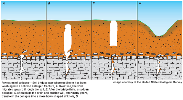
From 1970 to current date, the Missouri Department of Natural Resources investigated nearly 200 reported collapses, and found that most were less than 10 feet in diameter and depth.  (Kauffman, 2007)  However, there have been some documented that have covered numerous acres, and have caused massive property and ecosystem damage.  Recently in Missouri, there have been a few cities which have been experiencing an increase of the appearance of this nuisance; indeed, just a few years ago, an entire lake recently disappeared because as the result of a sinkhole.

Surrounded by a suburban subdivision, the 23-acre Lake Chesterfield in St. Louis drained in just a few days in 2004, after a sinkhole emerged in the lakebed.  (Currier, 2004) The man-made lake, and accompanying subdivision were built in the mid-1980s.  The only reported review of the structural integrity of the area had been through aerial photos taken by the county.  The photos did not indicate the presence of past sinkhole formation, or that the landscape would be prone to this sort of development.  As Glenn Powers, planning director for St. Louis County indicated, “These things happen.”  (Price, 2004) If there had been a minor, hidden collapse, it may have gone unnoticed by developers.  The water from the lake might have begun to seep into a small crack around an old overgrown sinkhole and only leaked out a thimble full of water every day for years, until just enough erosion occurred.  

In this scenario, once it reaches this point, it is much like someone pulling a plug on drain.  The Missouri Department of Natural Resources (MoDNR, 2004) reviewed this particular case, and found that the rock layers underlying lake were very “prone to solution activity.”  (MoDNR-176, 2008) This indicates that the areas have always been a prime candidate for sinkhole development, and intensive studies should have probably been done, prior to any development.  

Plans are being made to seal the sinkhole and refill the lake, at great cost to the homeowners of the subdivision.  As private property, the city is not obligated to restore the lake, or repair any damages done.  This is not an isolated episode, either.  Property owners are facing growing repair costs, as the incidents increase, especially in the southern part of the state, where karst terrain is most dominant.

Near Springfield, in 2006 a sinkhole measuring approximately 60 feet wide and 75 feet deep, opened and swallowed portions of a couple of homes in a half-block area in Nixa, Missouri.  One homeowner that lost half of house said that he had been reading the paper, when he heard a rumbling noise.  Initially, he thought that it was a thunder or something similar.  He was surprised to look out of his window and see part of his house, garage, and car swallowed by the earth.  

City spokesman, Bryan Newberry stated, “These homes had been there without problems until this point.”  (AP, 2006)  This is typical of sinkhole formation; they do not send up a warning flare prior to their arrival.  Small towns like Nixa and rural areas are ill prepared for situations such like this.  Building codes are either not in place, or because the construction is technically outside of city limits, do not apply.  

In a recent Geographic Information Systems (GIS) analysis, which accompanies this article, it was discovered that there are areas within Missouri, which are at a higher risk than others are, and Nixa is no exception.  Situated just a few miles immediately south of Springfield, the city sits squarely on one of these higher risk areas, and as recent as April 2008, new sinkholes have begun to form.  There are no existing regulations requiring developers to conduct research on the geology before construction.  Nixa city leaders have taken notice though and are beginning to discuss how to address the issue, considering changes to regulations concerning construction around sinkholes.  (KY3, 2008)

Another city, which has also been witnessing a steady increase in sinkhole activity, is Cape Girardeau.  As of April 2008, the city has recorded 20 collapses over the past nine months.  According to Ken Eftnick, Director of Development Services for the city, they “have been seeing one show up every week or so and don’t anticipate that changing anytime soon.”  (McNichol, 2008)  

Workers in the city continue efforts to stabilize and fill the sinkholes, but there really is no good way to fill a sinkhole and be certain it will not reappear.  They are finding it difficult to keep up though, as heavy rains and flooding continue in low-lying areas of the Mississippi River, near the Cape.  Documenting the sinkholes, through site visits and aerial photography, the Geographic Information Systems Coordinator for Cape Girardeau continues to attempt to make sense of it all.  The holes do appear related, and the cause is still a mystery, while property owner concerns mount.  

The biggest concern for the city is a wastewater treatment facility, which lies perilously close to the area that the collapses have been occurring.  Widespread contamination of precious groundwater and ecosystems would then be the biggest concern, should a collapse occur beneath this facility.  (Arnand, 2008) In the meantime, industry is adjusting.  Utility lines, both gas and electric, have had to be moved and Burlington-Northern Sante Fe Railroad has installed ground movement sensors to alert oncoming trains if there has been significant disturbance to the integrity of the rails.  At the local rock quarry, it is business as usual.


Sinkholes can be problematic enough without human intervention.  Research has drawn correlations between some of these sinkholes and human land-use practices, specifically as they relate to ground water pumping.  (Barnett, 2007)  In this case, the water pumped out is acting as buoyant for the ground surface above, helping it to maintain a relative degree of structural integrity.  When ground water is pumped out, the earth above it no longer has any sort of support, and the structure could collapse.  The same effect may be occurring in Cape Girardeau, with the river acting as the pump.  Higher than average precipitation and flooding could be the catalyst, causing the Mississippi River and its tributaries to swell and recede.  This action fills the gaps in the rock underground, and stabilizes it somewhat.  When the water retreats though, it leaves only air to support the ground above, disrupting previous structural integrity.  In addition, earth movement from minor earthquakes, as well as human disturbances, intensify shifting.


Cape LeCroix Creek, around which many of the sinkholes have been developing, indirectly empties into the Buzzi Unicem quarry.  Water from the creek disappears underground and reappears in the walls of the quarry, further eroding the rock layers during its underground journey.  Regular blasting at the quarry site may be compounding the problem.  When asked about the significance of the nearby quarry activity, the GIS coordinator for Cape Girardeau dismissed the idea as not particularly relevant to the current situation, and that the blasting was insignificant.  (Arnand, 2008) However, a visiting geology professor noted that there was regular significant scale blasting occurring at the quarry, and that alone could be enough to create the problem.  He indicated that during his brief visit, he could feel vibrations from the blasting, as much as a mile away.  (Hageman, 2008) Similar to a carefully balanced house of cards, these intense vibrations can cause the loose layers of rock to shift and settle.  Water may intrude, washing away particles that have filled gaps, and when blasting resumes, the underlying rock settles further.  If a significant gap opens in the rock layers under the ground, it could cause those rocks to shift and settle, resulting in a collapse.  

While scientists are known to not agree on just about everything from A to Z, this does lead to an interesting question.  Given the set of circumstances, is it possible that the public is being put at risk, in the interests of preserving a business, which is the “biggest employer and highest taxpayer in Cape Girardeau?”  (McNichol, 2008) There is no question that in order to dismiss the quarry as an antagonist to the problem, an impartial study should be conducted in and around the quarry.  The city recently reached out to the U.S. Army Corps of Engineers, to help identify and propose remediation to the problem.  

The U.S. Army Corps of Engineers will have its hands full, investigating the exact cause of the sudden increase in sinkhole activity.  For years, karst landscapes were ignored, except by mining and industry interests.  A notable few have done extensive studies, but when compared with other types of terrain, research has been lacking.  Perhaps, it has been the level of accessibility, or simply the basic assumption by everyday people that the ground is as solid as it will always be.  In either case, situations such as those in Cape Girardeau, have demanded that scientists turn their attention to the topic.  At the time that this article was initiated, there was very little to be found about sinkholes, excepting news reports, and a few in-depth geologic studies.  Since that time, numerous new studies have appeared each with their own hypothesis on the exact nature of this problem, and with a different approach to solving it.


The initial GIS analysis and mapping done in combination with this article reviewed the rock layers within Missouri, and their relationship to sinkhole incidents Using the latest GIS software, two separate analyses were conducted (refer to analysis maps at end of article).  The study only scratched the surface; excepting geology, no other factors that contribute to sinkhole development were considered in the analysis.  As with any science, confirmation of previous findings is essential to forming a solid base for future research.  The analysis did confirm that the state is indeed “textbook karst.”  (Elliott, 2008) The regions with the highest incident of sinkhole activity are comprised of Paleozoic era, Cambrian, Mississippian, and Ordovician systems.  These are some of the weakest rocks, when pitted against the scouring power of running water.  Future research can use the study as base to continue comparisons with the other factors, in order to narrow down the possibilities until a specific cause is identified.

Identifying the cause of sinkhole development could take years.  Many of the factors that contribute to this problem are not constants, and monitoring of these phenomenon will be essential in understanding their significance.  Until a cause and permanent solution can be agreed upon, there are measures that individuals living in affected areas can take to avoid the problems associated with these formations and avoid the disaster that has befallen some of the previously mentioned communities.  

the state of Missouri should initiate a thorough investigation of its karst regions and make recommendations to the local governments to regulate construction in these areas.  The local governments could then work towards identifying their own specific areas of concern and inform their citizens of potential hazards.  Findings should be communicated quickly, and in comprehensible terms.  As Assistant Professor of Geography, David Fox of Park University indicated during a brief interview, it is important that the message about geographic dangers “be communicated effectively to the general population [and] focus on real people and their personal relationship with the environment, so that they walk away with a better understanding of the impact.”  (2008)  Indeed, with a better understanding, there will be a lot fewer surprises, and might just save a life.  At minimum, property owners can take charge of the situation themselves, and attempt to understand the structural integrity of their property, and insure themselves appropriately.  Only through awareness, will sinkholes be more understood, and their effects on human habitation, be minimized. 

 References


EN306C: Advanced Expository and Research Writing

3rd Annual Research & Creative Arts Symposium

Saturday, May 10, 2008

Fatality on the Home Front

My “Fatality on the Home Front” Map displays the distribution of fatalities of the war in Iraq, according to their home state in the United States, in relation to the number of recruits from each state in 2004.  

The data for fatalities was collected from a well-referenced media source, iCasualties.com.  The data was imported to an Excel spreadsheet, where some fields needed standardization to remove anomalies, such as extra spaces before names.  A new field was added to provide a state abbreviation, since the “Place Name” that the database was to be geocoded against, had abbreviations and not full names.  All entries for individuals from outside of the 50 states were removed from the database, for simplification, and the database was ready to be geocoded.  The Place Name file was chosen from NationalAtlas.gov, an Address Locater was created, and the Fatality database was geocoded against that.  There were approximately 500 entries that had to be matched interactively.  After each of these cities located in Google Maps, the nearest city within each state, appearing in the Place Name file, was chosen to match against.

The geocoding results were then plotted on a base map of the United States, provided by NationalAtlas.gov.  Since point data can really only be displayed as points, I realized that I needed something for comparison.  First, I attempted to compare it to general population figures, but the numbers were too insignificant.  Then, I attempted to locate armed forces census data but discovered that their job profiles are buried in the regular job profiles of the census.  After much consideration, and a lot of searching, I discovered the 2004 new recruit data on StateMaster.gov.  I attempted to locate a wider range, but unfortunately the Department of Defense does not share that type of information, and it is not available in normal Census data.  I decided that since that was the first full year after the start of the war in Iraq, it would be an adequate statistic to measure against. 

Comparing the number of fatalities to the number of new recruits was relatively easy in ArcGIS, but the balance of the cartographic design was not so easy.  The first consideration was the thematic overly, or map type.  I chose a graduated color map, because I believe it displays data on a national level much more effectively than any other type of symbol map.  It is easy to see patterns and pick out disparities in the data.  For this, I believe it worked very well.  The second biggest consideration was a color ramp.  I wanted something that would go well with the data and represent something close to the idea of a fatality.  After sifting through each of the color ramps provided in ArcGIS, I decided on the one that had the deepest color of red, closest to that of blood, to signify the loss of the same.  I was not entirely happy with the pink at the low end, but in the scheme of things, it worked out to signify what it should; there was very little loss of blood/life.

The remainder of the design was primarily towards technical aspects.  Initially, I tried a graticule, but it seemed to interfere too much, so I discarded it.  For the purpose of this map, it was not particularly relevant, so much as the data in the map itself.  I also had Alaska and Hawaii represented, but they too interfered with being able to balance the map and the textual information adequately.  Since the numbers for these states were not particularly outstanding, I decided it would be just as well to display their specific numbers in a relative position on the map page.  Part of this might have been due to the projection chosen, but I feel as though I might have had the same problem no matter which project I choose.  The final choice for projection was Albers Equal Area Conic, since it is one of the accepted norms for representing the conterminous United States.  The legend became a small problem, after some inspection.  The data was not represented accurately in the first draft, because the numbers were whole numbers.  While this would be perfectly acceptable for the intended audience of the map, for data representation it was lacking a bit, and the legend was adjusted to display two decimal places.

The balance of the map page is mostly aesthetic.  For appearance alone, the major lakes of the United States were chosen, but later I realized that it completed the map’s representation of the “red, white & blue.”  The scale bar chosen displays a singular numerical width of 1000 kilometers.  Kilometers were chosen because it is the international standard, and I believe that all measures should correlate with those standards.  Label were placed on the states, though a few had to modified for appearance, such as Vermont and New Hampshire; their abbreviation is displayed.  The north arrow was chosen for its appearance, and to provide a general sense of direction.  The title and subtitle were chosen to reflect the appearance of the intended audience, a general news readership.  Text was discriminately for details about the data and its sources, and the Arial font for its clean and neat appearance.

The overall layout was simple and straightforward.  I chose a thin, unobtrusive neat line to border the map page at one inch from the margins.  All elements were arranged within the neat line for a good sense of balance.  In order to make the text stand out better, a slight drop shadow was added, kerning adjusted to 2 pixels, and a fine black “stroke over fill” edge added. For a finishing touch, I added the stock photo of an American flag, for a backdrop.  This photo was made to be mostly faded and transparent, so as not to distract from the content of the map page, while still giving the map a sense of patriotism, and honor those that had fallen.  


GGP330 - Cartography
3rd Annual Research & Creative Arts Symposium


Popular Variations